2012
NH3470 : Glascarnoch dam from the south
taken 12 years ago, 4 km W of Lubfearn, Highland, Scotland
This is 1 of 2 images, with title starting with Glascarnoch dam from the in this square
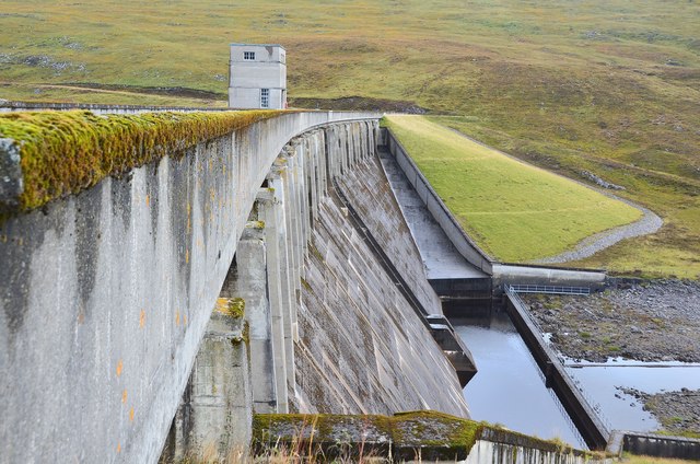
Glascarnoch dam from the south
The concrete gravity and earth-filled dam was completed in 1957.
Glascarnoch hydro scheme :: NH3172
Work started at the Glascarnoch site in 1953 and the dam was completed in 1957. There is no power station here but the loch collects water from Loch Droma to the W and via a tunnel from Loch Vaich to the N; the stored water is then transferred by tunnel southwards to the power station at Mossford near Grudie Bridge. More details are given in The Dam Builders by James Miller (Birlinn, Edinburgh 2010).
 Map © Crown Copyright")
TIP: Click the map for more Large scale mapping
- Grid Square
- NH3470, 65 images (more nearby 🔍)
- Photographer
- Jim Barton (more nearby)
- Date Taken
- Tuesday, 18 September, 2012 (more nearby)
- Submitted
- Sunday, 23 September, 2012
- Subject Location
-
OSGB36:
 NH 3455 7068 [10m precision]
WGS84: 57:41.7244N 4:46.6545W - Camera Location
-
OSGB36: NH 3447 7048
- View Direction
- North-northeast (about 22 degrees)