2012
TQ3181 : Farringdon station: view of Metropolitan Line tracks heading east
taken 11 years ago, near to London, The City of London, England
This is 1 of 61 images, with title starting with Farringdon Station in this square
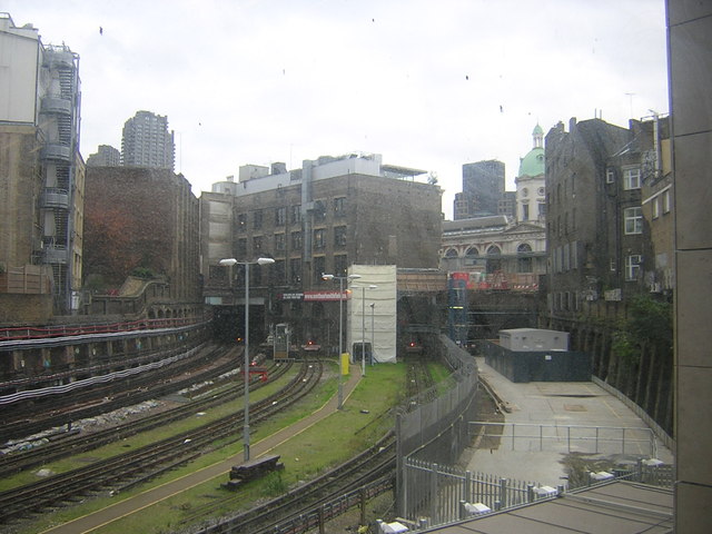
Farringdon station: view of Metropolitan Line tracks heading east
Redevelopment at Farringdon has extended the surface rail platforms south of Cowcross Street, opening up this view through a window along the Metropolitan Line tracks towards Barbican station.
On the right of the photo, the curving area of concrete marks what was previously the surface rail lines (the so-called "Widened Lines") through Barbican to Moorgate, track cut off and closed when the platforms at Farringdon were extended southwards towards City Thameslink across the eastward curve.
Visible above the tracks through a gap in the buildings, the dome of Smithfield Market, below which the tracks pass.
On the left, the brutalist concrete tower forms part of the Barbican development.
 Map © Crown Copyright")
TIP: Click the map for more Large scale mapping
- Grid Square
- TQ3181, 4259 images (more nearby 🔍)
- Photographer
- Christopher Hilton (more nearby)
- Date Taken
- Friday, 9 November, 2012 (more nearby)
- Submitted
- Friday, 9 November, 2012
- Subject Location
-
OSGB36:
 TQ 3167 8179 [10m precision]
WGS84: 51:31.1814N 0:6.2183W - Camera Location
-
OSGB36: TQ 3161 8180
- View Direction
- EAST (about 90 degrees)