2007
ST4676 : Stonework Architectural
taken 17 years ago, near to Portishead, North Somerset, England
Stonework Architectural
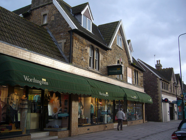
The context of Architecture Portishead High Street.
These stone and cut formed lintel and pillar houses became small shops and then stores until 2006 when proposals were made to alter the History and Quality of Portishead central to meet Corporate demands for emporia. At date the Architecture and therefore the History remain as a frontage, although badly damaged by protrusions and pigeon fencing, however under Heritage Regulations it should be possible for these to be cleaned up to a clear face and the stonework retained in the new development proposed for the shop site which can easily fit behind the main walls and windows, it facing a modern open car park, main road and another proposed multi-store complex and the Health Centre, into the back gardens of these houses. The built form is stable. Comments and advice, from concerned residents and visitors to this Historic town, could be made to North Somerset District Council at Weston Super Mare, Planning. There are several other different styles that need photographic record, this is just one of the better in quality.
These stone and cut formed lintel and pillar houses became small shops and then stores until 2006 when proposals were made to alter the History and Quality of Portishead central to meet Corporate demands for emporia. At date the Architecture and therefore the History remain as a frontage, although badly damaged by protrusions and pigeon fencing, however under Heritage Regulations it should be possible for these to be cleaned up to a clear face and the stonework retained in the new development proposed for the shop site which can easily fit behind the main walls and windows, it facing a modern open car park, main road and another proposed multi-store complex and the Health Centre, into the back gardens of these houses. The built form is stable. Comments and advice, from concerned residents and visitors to this Historic town, could be made to North Somerset District Council at Weston Super Mare, Planning. There are several other different styles that need photographic record, this is just one of the better in quality.
 Map © Crown Copyright")
TIP: Click the map for more Large scale mapping
- Grid Square
- ST4676, 174 images (more nearby 🔍)
- Photographer
- MDS (more nearby)
- Date Taken
- Monday, 12 February, 2007 (more nearby)
- Submitted
- Tuesday, 13 February, 2007
- Subject Location
-
OSGB36:
 ST 467 763 [100m precision]
WGS84: 51:29.0150N 2:46.0949W - Camera Location
-
OSGB36: ST 467 763
- View Direction
- SOUTH (about 180 degrees)