NY5737 : Geophysical survey, Long Meg & Her Daughters
taken 11 years ago, near to Little Salkeld, Cumbria, England
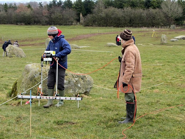
Part of a topographic, geophysical and photographic survey of Long Meg & Her Daughters for the Altogether Archaeology Project of the North Pennines Area of Outstanding Natural Beauty in March 2013.
The stone circle known has Long Meg and Her Daughters is one of the biggest stone circles in Britain with a diameter between 93 and 110 metres, flattened on one side (where it aligns with the infilled ditch of a large enclosure, now only visible on aerial photographs). The circle has 69 irregularly shaped stones (26 standing) of the igneous rock rhyolite, some containing large amounts of quartz, and are considered to be glacial erratics. There is a fine aerial view here NY5737 : Long Meg and her Daughters, Eden Valley, Cumbria
Long Meg is a 3.6 metres high pillar of red sandstone, possibly quarried from the banks of the nearby river Eden. It stands 20 metres outside the south-west circle entrance, in line with the setting sun at the winter solstice as viewed from the centre of the circle. Other large stones at points around the perimeter may mark other alignments. The monolith is carved on the east side with motifs including incised grooves, concentric circles and a spiral.
Modern Antiquarian Link
 Map © Crown Copyright")
- Grid Square
- NY5737, 127 images (more nearby 🔍)
- Photographer
- Andrew Curtis (more nearby)
- Date Taken
- Thursday, 21 March, 2013 (more nearby)
- Submitted
- Saturday, 23 March, 2013
- Subject Location
-
OSGB36:
 NY 5707 3724 [10m precision]
WGS84: 54:43.6981N 2:40.0872W - Camera Location
-
OSGB36: NY 5704 3724
- View Direction
- EAST (about 90 degrees)