2010
ST1140 : Looking down from Staple Plain
taken 14 years ago, near to West Quantoxhead, Somerset, England
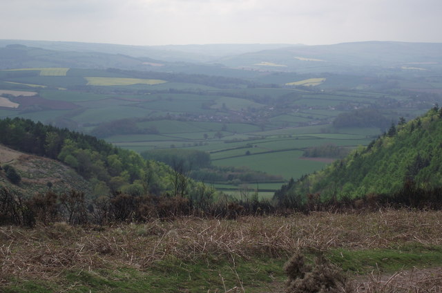
Looking down from Staple Plain
The view from a point close to the Staple Plain Car Park on the Quantock Hills. The viewpoint is bounded by the two gullies that form the head of the Weacombe valley. The settlement in the middle ground is Sampford Brett, with some straggly suburbs of Williton also visible a bit further to the right. Further back we can see the foothills of the Brendon Hills. Skyline left is Exmoor. Skyline right is Croydon Hill. It seems the Exmoor peak of Dunkery Beacon is just visible where the two skylines intersect.
 Map © Crown Copyright")
TIP: Click the map for more Large scale mapping
- Grid Square
- ST1140, 23 images (more nearby 🔍)
- Photographer
- Stephen Wilks (more nearby)
- Date Taken
- Friday, 7 May, 2010 (more nearby)
- Submitted
- Wednesday, 10 April, 2013
- Subject Location
-
OSGB36:
 ST 116 409 [100m precision]
WGS84: 51:9.6519N 3:15.8813W - Camera Location
-
OSGB36: ST 117 409
- View Direction
- West-southwest (about 247 degrees)