2013
NG7705 : Looking northwest from west top of Meall Coire an t-Searraich
taken 11 years ago, 3 km from Inverguseran, Highland, Scotland
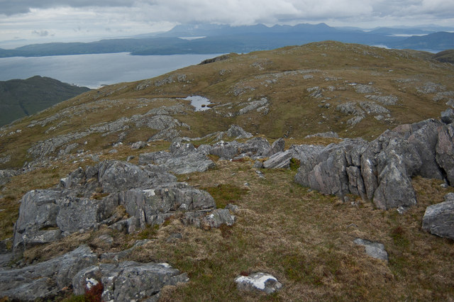
Looking northwest from west top of Meall Coire an t-Searraich
Taken from the west top of Meall Coire an t-Searraich (681 metre spot-height on OS 1:25 000 mapping), the photo shows the north eastern part of grid square NG7705. The tiny lochan sits in a shallow col between the photographer's viewpoint, and the slightly lower top to the northwest. The lochan (one of two) is marked on 1:25 000 OS mapping, but not on 1:50 000 maps. To the southwest (left side of the photo), the hillside gradually drops away into the valley (Gleann na Guiserein, not visible in the photo), into which the lochan drains.
The view in the background looks out across the Sound of Sleat, across the Sleat Peninsula on the Isle of Skye, and finally to the Black Cuillin mountains (tipped with cloud) and Red Cuillin mountains, on the Isle of Skye.
The view in the background looks out across the Sound of Sleat, across the Sleat Peninsula on the Isle of Skye, and finally to the Black Cuillin mountains (tipped with cloud) and Red Cuillin mountains, on the Isle of Skye.
 Map © Crown Copyright")
TIP: Click the map for more Large scale mapping
- Grid Square
- NG7705 (more nearby 🔍)
- Photographer
- Paul (more nearby)
- Date Taken
- Monday, 24 June, 2013 (more nearby)
- Submitted
- Tuesday, 2 July, 2013
- Subject Location
-
OSGB36:
 NG 77626 05756 [1m precision]
WGS84: 57:5.3341N 5:40.3148W - Camera Location
-
OSGB36: NG 77772 05680
- View Direction
- West-northwest (about 292 degrees)