2013
SN5982 : Penglais Road
taken 11 years ago, near to Aberystwyth, Ceredigion/Sir Ceredigion, Wales
This is 1 of 3 images, with title Penglais Road in this square
Penglais Road
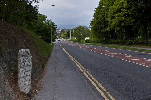
on the A487, the main road into Aberystwyth for traffic from the north, looking down towards the town with the castle silhouetted against the sea.
For close ups of the milestone on the left, see SN5982 : Milestone, Penglais Road and SN5982 : Milestone, Penglais Road. It is one of three similar stones situated a mile from Aberystwyth on each of the main roads into the town, all dating from the 19th century. See SN5981 : Quebec Road and SN5880 : Penparcau Road/First Avenue for the sites of the other two, in Quebec Road and Penparcau Road respectively.
For close ups of the milestone on the left, see SN5982 : Milestone, Penglais Road and SN5982 : Milestone, Penglais Road. It is one of three similar stones situated a mile from Aberystwyth on each of the main roads into the town, all dating from the 19th century. See SN5981 : Quebec Road and SN5880 : Penparcau Road/First Avenue for the sites of the other two, in Quebec Road and Penparcau Road respectively.
 Map © Crown Copyright")
TIP: Click the map for more Large scale mapping
- Grid Square
- SN5982, 97 images (more nearby 🔍)
- Photographer
- Ian Capper (more nearby)
- Date Taken
- Friday, 31 May, 2013 (more nearby)
- Submitted
- Saturday, 24 August, 2013
- Subject Location
-
OSGB36:
 SN 596 820 [100m precision]
WGS84: 52:25.1143N 4:3.8799W - Camera Location
-
OSGB36: SN 597 820
- View Direction
- WEST (about 270 degrees)