2013
TQ6632 : Panorama of Bewl Water Reservoir
taken 11 years ago, near to Cousley Wood, East Sussex, England
This is 1 of 2 images, with title Panorama of Bewl Water Reservoir in this square
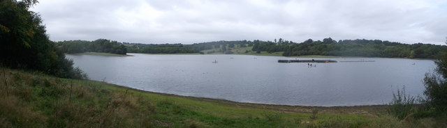
Panorama of Bewl Water Reservoir
As seen from near to Hook Hill.
Great Hook Wood is seen across the reservoir and many fishing boats.
Great Hook Wood is seen across the reservoir and many fishing boats.
Bewl Water Reservoir
Laying on the Kent and East Sussex border, the reservoir was created between 1973 and 1975, and is the largest inland area of water in the South East of England.
To create the reservoir a 300m long dam was built and a large number of buildings had to be demolished, including some listed buildings which were relocated.
There is a visitor centre and café, boat rides, sailing club, and fishing areas. There is a 13 mile (depending on route) bridleway and footpath around the reservoir.
Wikipedia Link
 Map © Crown Copyright")
TIP: Click the map for more Large scale mapping
- Grid Square
- TQ6632, 79 images (more nearby 🔍)
- Photographer
- David Anstiss (more nearby)
- Date Taken
- Saturday, 21 September, 2013 (more nearby)
- Submitted
- Tuesday, 24 September, 2013
- Subject Location
-
OSGB36:
 TQ 6685 3297 [10m precision]
WGS84: 51:4.3085N 0:22.8111E - Camera Location
-
OSGB36: TQ 6695 3289
- View Direction
- Northwest (about 315 degrees)