NS4863 : Paisley Abbey: the choir
taken 11 years ago, near to Paisley, Renfrewshire, Scotland
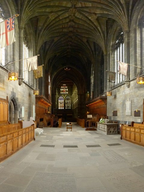
Near the left-hand edge of the picture is the entrance to the old sacristy, now functioning as the sacristy museum. The back of a cardboard cut-out of a monk can be seen beside that entrance. Visible behind the cut-out is the tomb of King Robert III; the tomb was lying in the same spot when this area was covered in grass and open to the sky. See NS4863 : Paisley Abbey: tomb of King Robert III.
One thing that was not then located here was the so-called tomb of Marjory Bruce, which can be seen, with flowers on top of it, on the other wall, directly opposite the tomb of Robert III. See NS4863 : Paisley Abbey: tomb of Marjory Bruce.
(The restoration of the choir was part of the work that was carried out on the Abbey from 1912-28, although with an interruption during the First World War.)
Just beyond the more distant of the wooden choir stalls is the crossing. The nave, largely in darkness, is beyond that; the stained glass windows in the distance are at the far end of the nave. In this picture, it is possible to discern that the nave is not quite on the same line as the choir; relative to the choir, the nave deflects a little to the south (the left).
The picture also shows part of the vaulted ceiling. There are many details of interest up there, although, for most visitors, it would require the aid of binoculars to fully appreciate these.
See NS4863 : Paisley Abbey: the choir for a view along the choir in the opposite direction.
As for the gravestones incorporated in the pavement, these are described by Howell in his work cited in the end-note. They are also listed, though in a compact format which gives the essential details only, rather than a full transcription, in one of the MI volumes: "Renfrewshire Monumental Inscriptions (pre-1855) Volume 2" (ed. J F & S Mitchell, for the Scottish Genealogy Society, 1992). Many of the inscriptions in the burial grounds outside the abbey are transcribed in the same work.
The abbey's website Link
provides a summary of its history, and other information.
It is thought that an early religious community was established at Paisley by St Mirin. In the twelfth century, Walter FitzAlan, High Steward of Scotland, had a priory established on his lands in Paisley, to be founded by monks of the Cluniac order; one of Walter's charters confirms certain lands "to God and Saint Mary, and the church of St James, and St Mirin, and St Myldburge de Passelet [Paisley], and to the priors and monks serving God there according to the order of Clugny".
[The name Paisley is thought to be derived, via either a Gaelic or a Cumbric form, from the Latin word 'basilica'. Such a derivation would indicate that the place already had ecclesiastical importance long before that priory was founded. See the short article "Paisley" by W.J.Watson (d.1948) in his "Place-Name Papers" (collection published in 2002).]
In its design, the original priory was modelled on the Abbey of Cérise in France. The religious establishment at Paisley was elevated to the status of an abbey in 1245, after lengthy negotiations.
The abbey suffered grievous damage during the Wars of Independence: according to an annal entry (here translated from the original Latin), "in this year, 1307, the English burnt the Monastery of Paisley"; nothing remained but blackened walls. Some repair work was started in 1317, but little progress was made for several decades: however, by 1389-90, we have notice of glass being purchased for the abbey's windows, showing that repairs were then well under way.
A great deal of rebuilding was carried out during the time of Abbot Thomas Tervas (mid-fifteenth century), and, a little later, by Abbot George Shaw. The buildings appear to have been damaged by fire towards the end of the same century. It also seems that, at some point in the abbey's history, its central tower collapsed, damaging adjacent structures.
At the time of the Reformation (1560), the damage done to the abbey was limited, perhaps partly because the building was already in poor condition.
Subsequent developments will not be described here in detail, but it is worth noting several restorations of the abbey that were carried out in recent centuries: (1) 1788-89, under the supervision of Dr Robert Boog, minister of the First Charge at the Abbey (Boog was also responsible for piecing together what is now called the Tomb of Marjorie Bruce); (2) 1859-62, under ministers Andrew Wilson and J Cameron Lees; (3) 1898-1907, under the ministers Thomas Gentles and J B Dalgety; and (4) 1912-28 (but interrupted in 1918 by the War), under A M Maclean and W Fulton. See Howell, cited below, for details.
In the 1990s, the Great Drain below the abbey was rediscovered (see Malden, cited below); it has subsequently yielded many interesting artefacts, some of which are now displayed in the Sacristy Museum, within the abbey.
Selected references:
▪ "Historical Description of the Abbey and Town of Paisley", Charles Mackie (1835).
▪ "The Abbey of Paisley", J Cameron Lees (1878).
▪ "Paisley Abbey: Its History, Architecture, & Art", Rev A R Howell (1929).
▪ "The Monastery and Abbey of Paisley" (various contributors), edited by John Malden (2000).
 Map © Crown Copyright")
- Grid Square
- NS4863, 1052 images (more nearby 🔍)
- Photographer
- Lairich Rig (more nearby)
- Date Taken
- Monday, 22 July, 2013 (more nearby)
- Submitted
- Monday, 30 September, 2013
- Subject Location
-
OSGB36:
 NS 4858 6395 [10m precision]
WGS84: 55:50.6953N 4:25.1968W - Camera Location
-
OSGB36: NS 4859 6395
- View Direction
- WEST (about 270 degrees)