NU1813 : Robertson's Pant (or fountain)
taken 11 years ago, near to Alnwick, Northumberland, England
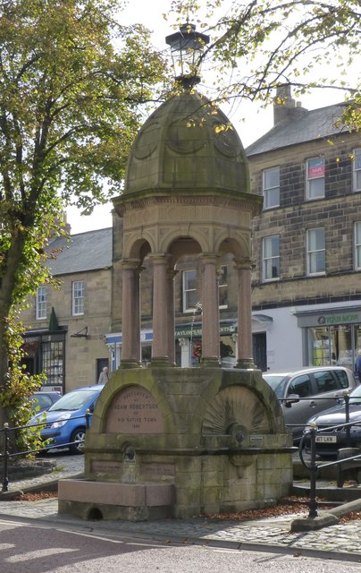
Presented by Adam Robertson to his native town 1890.
On a large square base with octagonal domed tempietto. Pointed ribbed dome with circular panels between ribs; lamp supported above done. East and west faces of base have fanned panels, to north a semi-circular porphyry tablet inscribed "Presented by Adam Robertson to his native town" and smaller plaques below inscribed "opened by Earl Percy" and "June 8th 1891"
For detail of the dome see: Link
Alnwick's water was originally supplied by streams and a couple of wells. A number of roads in the town follow the course of the original streams (Clayport, Hotspur Street, Wagonway Road, Canongate, Greenwell Lane and Bow Alley). The streams were not completely covered over until 1827. As they were, the water was routed through public water fountains called pants.
Alnwick flourished in the middle of the 18th century. The town became an important staging point on the Great North Road, and on the turnpike road between Hexham and Alnmouth. More pants were constructed during this period, to serve an increasingly prosperous population (Tower Well Pant:1752, Green Batt Pant:1753, clayport Pant: 1755, St Michael's Pant: 1759, Church Pant, 1778)
By the middle of the 19th century the pants were unable to provide sufficient clean water for a rapidly growing population. After a serious outbreak of Cholera in 1849 piped water was introduced. By the end of the 1850's this was to supply most of the town's needs. In the last 150 years some of the old pants have been replaced, some removed, and some destroyed by vehicles, but most are still maintained. They can still be appreciated as important features of the townscape.
Thanks to Alnwick Civic Society for permission to use information from their website:
Link
 Map © Crown Copyright")
- Grid Square
- NU1813, 725 images (more nearby 🔍)
- Photographer
- Russel Wills (more nearby)
- Date Taken
- Monday, 30 September, 2013 (more nearby)
- Submitted
- Monday, 30 September, 2013
- Subject Location
-
OSGB36:
 NU 1869 1327 [10m precision]
WGS84: 55:24.7801N 1:42.3807W - Camera Location
-
OSGB36: NU 18694 13280
- View Direction
- Southeast (about 135 degrees)