2013
TQ3084 : Caledonian Road underground station: platform-level signage
taken 11 years ago, near to Islington, England
This is 1 of 2 images, with title Caledonian Road underground station: platform-level signage in this square
Caledonian Road underground station: platform-level signage
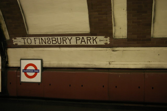
At the time that this stretch of the Piccadilly Line was built, as one of the early deep-level tubes, a visual and conceptual grammar of signage was still being worked out by the companies involved. Caledonian Road enshrines an experiment that did not catch on, signs pointing towards the then-termini to indicate which direction a particular platform's trains would be going.
 Map © Crown Copyright")
TIP: Click the map for more Large scale mapping
- Grid Square
- TQ3084, 279 images (more nearby 🔍)
- Photographer
- Christopher Hilton (more nearby)
- Date Taken
- Monday, 30 September, 2013 (more nearby)
- Submitted
- Tuesday, 1 October, 2013
- Subject Location
-
OSGB36:
 TQ 3055 8496 [10m precision]
WGS84: 51:32.9063N 0:7.1159W - Camera Location
-
OSGB36: TQ 3055 8496
- View Direction
- West-northwest (about 292 degrees)