2013
TF3859 : Switchback road alongside Hobhole Drain
taken 11 years ago, near to Midville, Lincolnshire, England
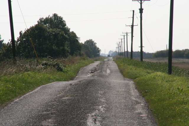
Switchback road alongside Hobhole Drain
Roads alongside drains are prone to subsidence.
Hobhole is a big, deep drain. In about 2008 I was driving northwards along the east bank (this is the west bank, but it is as bad), at less than 30mph, but nevertheless hit such a bad patch that I was thrown onto the verge, and found myself looking down into the murky depths of the drain below. I filed a complaint with the local highways authority (there wasn't so much as a bumpy road sign at the ends of the road). In spite of this, shortly afterwards a family in a car went off the road and drowned. Now there are bumpy road signs on both banks, and a 30mph sign has appeared on the east bank, where some of the bumps have also been ironed out.
Hobhole is a big, deep drain. In about 2008 I was driving northwards along the east bank (this is the west bank, but it is as bad), at less than 30mph, but nevertheless hit such a bad patch that I was thrown onto the verge, and found myself looking down into the murky depths of the drain below. I filed a complaint with the local highways authority (there wasn't so much as a bumpy road sign at the ends of the road). In spite of this, shortly afterwards a family in a car went off the road and drowned. Now there are bumpy road signs on both banks, and a 30mph sign has appeared on the east bank, where some of the bumps have also been ironed out.
 Map © Crown Copyright")
TIP: Click the map for more Large scale mapping
- Grid Square
- TF3859, 13 images (more nearby 🔍)
- Photographer
- Chris (more nearby)
- Date Taken
- Saturday, 28 September, 2013 (more nearby)
- Submitted
- Tuesday, 8 October, 2013
- Subject Location
-
OSGB36:
 TF 3874 5904 [10m precision]
WGS84: 53:6.6306N 0:4.2749E - Camera Location
-
OSGB36: TF 3878 5928
- View Direction
- SOUTH (about 180 degrees)