TF2122 : Bylaws for the drainage of Deeping Fen
taken 11 years ago, near to Pode Hole, Lincolnshire, England
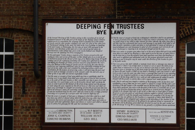
See this notice in context at TF2122 : Historic engine house
The Fens, also known as the Fenland, is a naturally marshy region in eastern England. Most of the fens were drained several centuries ago, resulting in a flat, damp, low-lying agricultural region.
A fen is the local name for an individual area of marshland or former marshland and also designates the type of marsh typical of the area, which has neutral or alkaline water chemistry and relatively large quantities of dissolved minerals, but few other plant nutrients.
Fenland primarily lies around the coast of the Wash; it reaches into four counties: Lincolnshire, Cambridgeshire, Norfolk and a small area of Suffolk, as well as the historic county of Huntingdonshire. In whole it occupies an area of nearly 1,500 sq miles.
Most of the Fenland lies within a few metres of sea level. As with similar areas in the Netherlands, much of the Fenland originally consisted of fresh- or salt-water wetlands, which have been artificially drained and continue to be protected from floods by drainage banks and pumps.
 Map © Crown Copyright")
- Grid Square
- TF2122, 67 images (more nearby 🔍)
- Photographer
- Bob Harvey (more nearby)
- Date Taken
- Wednesday, 9 October, 2013 (more nearby)
- Submitted
- Wednesday, 9 October, 2013
- Subject Location
-
OSGB36:
 TF 2135 2201 [10m precision]
WGS84: 52:46.9223N 0:12.1348W - Camera Location
-
OSGB36: TF 2133 2199
- View Direction
- Northeast (about 45 degrees)