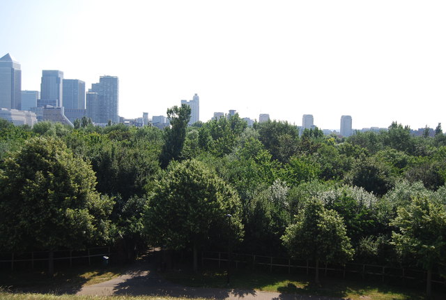
TQ3679 : View SE from Stave Hill
taken 11 years ago, near to Stepney, Tower Hamlets, England
Stave Hill is an artificial hill adjacent to the 5.2-acre Stave Hill Ecological Park, it is part of Russia Dock Woodland. The woodland park occupies land that was previously Russia Dock and Stave Dock, both part of the Surrey Commercial Docks, which were filled in during the mid-1980s and then redeveloped by the London Docklands Development Corporation.
Stave Hill is a 9m high artificial mound in the shape of a truncated cone, with a viewing platform and relief map of the former docks in cast bronze by Michael Rizzello at the top. It provides remarkable views over Canary Wharf, the City of London, and much of south and central London; on clear days the view stretches as far as Wembley Stadium.
It was created in 1985 by the LDDC, using spoil from the works to fill and landscape the areas formerly occupied by commercial docks.
Russia Dock Woodland is a long narrow park in Rotherhithe, London, created by the infilling of one of the former Surrey Commercial Docks. The former Russia Dock was originally used for the importing of timber from Norway, Russia and Sweden.
Following the closure of the docks in the early 1970s, the area was redeveloped by the London Docklands Development Corporation (LDDC). Russia Dock Woodland was made up of a number of docks, including Russia Dock, Island Dock and Surrey Basin, which were infilled (save for a thin 'stream' through the woodland) and planted as a 34.5-acre woodland in 1980. The Woodland still contains surviving dock features including the retaining wall capstones, depth gauges, bollards, mooring chains and tracks. In 1985 the LDDC added an artificial hill, Stave Hill, to the west edge of the park, using waste material and rubble. A relief map of the former docks in cast bronze by Michael Rizzello stands at the top of the hill.
 Map © Crown Copyright")
- Grid Square
- TQ3679, 590 images (more nearby 🔍)
- Photographer
- N Chadwick (more nearby)
- Date Taken
- Sunday, 7 July, 2013 (more nearby)
- Submitted
- Friday, 11 October, 2013
- Subject Location
-
OSGB36:
 TQ 3622 7977 [10m precision]
WGS84: 51:30.0276N 0:2.3328W - Camera Location
-
OSGB36: TQ 3610 7983
- View Direction
- East-southeast (about 112 degrees)