TL4558 : Almshouse, King St
taken 10 years ago, near to Cambridge, Cambridgeshire, England
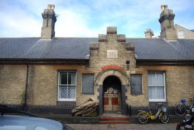
Also known as Knight's and Mortlocks Almshouses.
See the following link for information on these almshouses. Link
King Street is in central Cambridge. It connects between Sussex Street heading west and Hobson Street heading south at the western end and a large roundabout to the east. It runs parallel to and south of Jesus Lane.
Sidney Sussex College backs on to the street to the northwest. Christ's College is to the south, with some of its more recent buildings on the street.
The street has four pubs on it (fewer than it did have) and is the venue for the King Street Run. Link
The pubs are:
Cambridge Brewhouse TL4558 : Cambridge Brewhouse, King St
Champion of the Thames TL4558 : The Champion of The Thames
The King Street Run TL4558 : The King Street Run
St Radegund TL4558 : St Radegund
Almshouses are charitable housing provided to enable people (typically elderly people who can no longer work to earn enough to pay rent) to live in a particular community. They are often targeted at the poor of a locality, at those from certain forms of previous employment, or their widows, and are generally maintained by a charity or the trustees of a bequest.
Alms are, money or services donated to support the poor and indigent. Almshouses were established from the 10th century in Britain, to provide a place of residence for poor, old and distressed folk. The first recorded almshouse was founded in York by King Athelstan; the oldest still in existence is the Hospital of St. Cross in Winchester, dating to about 1132. In the Middle Ages, the majority of European hospitals functioned as almshouses.
An incomplete list of British Almshouses can be found at Link
 Map © Crown Copyright")
- Grid Square
- TL4558, 4563 images (more nearby 🔍)
- Photographer
- N Chadwick (more nearby)
- Date Taken
- Saturday, 26 October, 2013 (more nearby)
- Submitted
- Thursday, 16 January, 2014
- Subject Location
-
OSGB36:
 TL 4537 5872 [10m precision]
WGS84: 52:12.4521N 0:7.5617E - Camera Location
-
OSGB36: TL 4538 5870
- View Direction
- North-northwest (about 337 degrees)