SU6414 : The southern end of Hambledon
taken 10 years ago, near to Hambledon, Hampshire, England
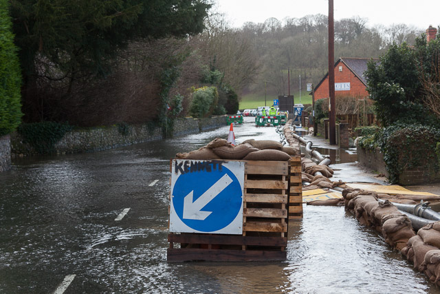
The village of Hambledon floods quite regularly, after prolonged rainfall has raised the water table in the underlying chalk. Unlike the floods at Morestead Link or Hensting Lane Link , which are simply caused by water running off the land and flowing on the surface, the flooding at Hambledon is more complicated.
Although there is some water flowing on the surface, the primary problem is caused by water bubbling up from the ground. Residents have to pump continuously to clear water from their cellars or simply from beneath their ground floor. Any failure of those pumps causes flooding of ground floor rooms.
There is a further problem caused by the surface water, which is clean, augmented by that pumped out of cellars, finding its way into the foul sewer that runs along West Street and the B2150 Hambledon Road. This overloads the sewer and causes sewage to appear in people's houses unless mitigating action is taken. The technique is to use about eight powerful diesel pumps, each capable of pumping about 340 cubic metres per hour, to run a kind of relay race, pumping water out of one sewer manhole and into the next one along on the downstream side. In this way the capacity of the sewer is temporarily increased. Sandbags are used around manholes to reduce the amount of surface water that enters the sewer.
All this pumping activity has to go on 24/7 for six weeks or longer, during which time the village is closed to traffic. Despite this effort, water and sewage had entered the downstairs rooms of 10 properties by the end of the flood.
Due to its past experience, the village is well organised for dealing with flooding. It has a flood incident room and volunteers in radio contact coordinating action. A daily Flood Update newsletter is produced.
Longer term, the village is seeking the construction of a 1m diameter drainage pipe down West Street. The purpose of this, I presume, would be to take all surface flood water and prevent it running along the road surface and thence getting into the sewer and overloading it. It is unclear if this 1m pipe would obviate the need to pump out cellars; I think not. The cost of the pipe is said to be £3.5m, to protect 140 properties, a figure well outside the Treasury rules for flood prevention investment. However, there has been no investment in any flood amelioration scheme in Hambledon for 70 years, and the proposed spending of £10m for flood prevention on the Somerset Levels would protect fewer people, residents claim. Hambledon was not included in the £130m flood defence package announced in early February by Floods Minister Dan Rogerson. Hampshire County Council has offered to fund half the cost of the proposed pipe, but the Environment Agency is still precluded from taking up this offer.
 Map © Crown Copyright")
- Grid Square
- SU6414, 138 images (more nearby 🔍)
- Photographer
- Peter Facey (more nearby)
- Date Taken
- Saturday, 8 February, 2014 (more nearby)
- Submitted
- Thursday, 6 March, 2014
- Subject Location
-
OSGB36:
 SU 6416 1460 [10m precision]
WGS84: 50:55.6377N 1:5.3076W - Camera Location
-
OSGB36: SU 6417 1464
- View Direction
- South-southwest (about 202 degrees)