2014
TQ1470 : Upper Lodge in Bushy Park
taken 10 years ago, near to Teddington, Richmond Upon Thames, England
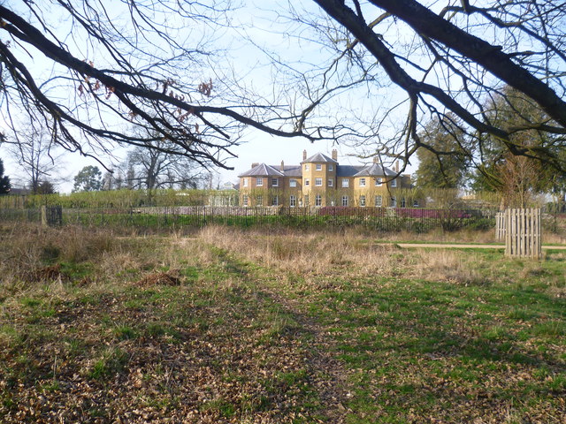
Upper Lodge in Bushy Park
Bushy was one of the three parks enclosed by Cardinal Wolsey in the early 16th century as part of his Hampton Court estate which was built from 1515 and given to Henry VIII along with the palace in 1525. In 1638-9 Charles I had a tributary of the River Colne diverted through Bushy Park to form the Longford River, bringing water right into the grounds of Hampton Court Palace. This provided a water supply for the numerous water features in the parks. Numerous smaller ponds and other water features in Bushy Park have been added at various times since the 16th century.
This view is from the London LOOP which runs right across Bushy Park and looks towards Upper Lodge. Charles Montagu, Earl of Halifax was Ranger of Bushy Park in the early 18th century. In 1710 he rebuilt his official residence, Upper Lodge, and set about improving the grounds.
Upper Lodge and its grounds were later used for many purposes. It became a home for soldiers families in the First World War and then a hospital for returning Canadian soldiers. Then it became a convalescent home for boys from the East End of London when it was called the Kings Canadian School and then barracks for airmen from the United States Eighth Army Air Force from 1941. It was then a research establishment on lease from the Crown Estate to the Admiralty from 1944 to 1994.
 Map © Crown Copyright")
TIP: Click the map for more Large scale mapping
- Grid Square
- TQ1470, 134 images (more nearby 🔍)
- Photographer
- Marathon (more nearby)
- Date Taken
- Wednesday, 12 March, 2014 (more nearby)
- Submitted
- Friday, 14 March, 2014
- Subject Location
-
OSGB36:
 TQ 1461 7063 [10m precision]
WGS84: 51:25.3862N 0:21.1813W - Camera Location
-
OSGB36: TQ 1464 7059
- View Direction
- North-northwest (about 337 degrees)