TQ3783 : 2012 Olympic Stadium from the air
taken 10 years ago, near to Bow, Tower Hamlets, England
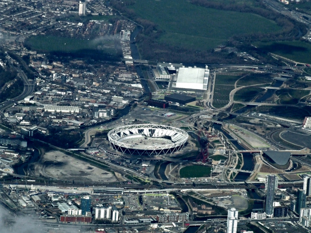
This is a sporting complex is being used for the 2012 Summer Olympics and the 2012 Summer Paralympics, situated to the east of the city adjacent to the Stratford City development. It contains the athletes' Olympic Village and several of the sporting venues including the Olympic Stadium and Aquatics Centre. The park is overlooked by ArcelorMittal Orbit, an observation tower and Britain's largest piece of public art. After the Olympics, the park will be known as Queen Elizabeth Olympic Park, to commemorate the Diamond Jubilee of Elizabeth II.
See Linkfor more details on the various parts of the park.
Lee Valley Park is a 10,000 acre, 26 miles long linear park, much of it green spaces, running through the northeast of London, Essex and Hertfordshire from the River Thames to Ware, through areas such as Hackney, Tottenham, Enfield, Stratford, Tower Hamlets, Walthamstow, Cheshunt, Broxbourne and Hoddesdon in an area generally known as the Lee Valley. London's largest park, Lee Valley Park is more than four times the size of Richmond Park, extending beyond London's borders into the neighbouring counties of Hertfordshire and Essex.
The park follows the course of the River Lea (Lee) along the Lea Valley from Ware in Hertfordshire through Essex and North East London, through the Queen Elizabeth Olympic Park to East India Dock Basin on the River Thames. The park is managed by Lee Valley Regional Park Authority and is made up of a diverse mix of countryside areas, urban green spaces, heritage sites, country parks, nature reserves and lakes and riverside trails, as well as leading sports centres.
A 53 mile long route mainly on riverside paths, linking the source near the Icknield Way Path east of the Dunstable Downs to the London Docklands. It first follows the course of the river, which is variously spelt Lee and Lea, and then after a suburban diversion from the river at Welwyn, it takes the canalised navigations from Hertford, using wherever possible green waterside corridors. It passes the numerous reservoirs that line the Lea valley through North London.
It incorporates the Upper Lea Valley Walk (9 miles and on OS mapping), the Cole Green Way west of Hertford, a multi-user trail including the route of a disused railway, and the Lee Navigation towpath.
From the source at Leagrave, suburban walking in Luton soon leads to countryside and a mainly rural stretch to Hertford where the canalised section starts, with in the same valley corridor the New River Path, also canalised, branching off earlier. Further south a series of large man-made embanked reservoirs lie to the east of the Lea, that continues into east London through marshland reserves rich in wildlife and in green spaces, finally passing close by the west side of the Olympic Park site to reach Bow Locks. From here either the Limehouse Cut or cycling routes along the Lea river can be used to reach the Thames. The short Hertford Union Canal (c. 1.5km) links the River Lea Navigations and the Regent's Canal along the southern side of Victoria Park.
 Map © Crown Copyright")
- Grid Square
- TQ3783, 501 images (more nearby 🔍)
- Photographer
- Thomas Nugent (more nearby)
- Date Taken
- Tuesday, 18 March, 2014 (more nearby)
- Submitted
- Tuesday, 18 March, 2014
- Subject Location
-
OSGB36:
 TQ 37 83 [1000m precision]
WGS84: 51:32.0201N 0:1.1398W