2014
SE2800 : The South end of the 1947 Huthwaite Tunnel
taken 10 years ago, near to Thurgoland, Barnsley, England
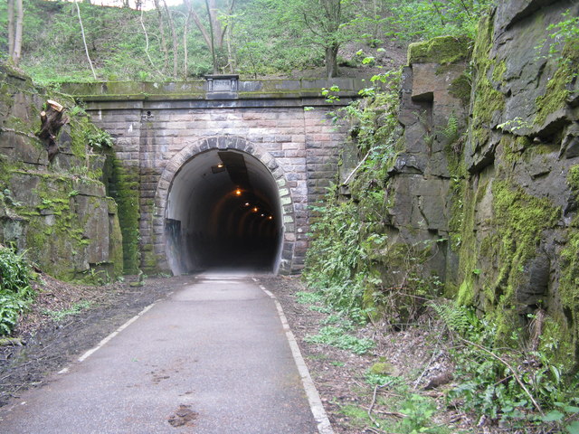
The South end of the 1947 Huthwaite Tunnel
The original Huthwaite Tunnel (315 yards) was built in 1844. It had two tracks. Stone was used for both its lining and portals. The tunnel which is now part of the TPT was built as a result of the electrification of the Woodhead line, as the original tunnel could not include two tracks worth of overhead line equipment (OLE). Nationalisation of the railways occurred during the construction resulting in both LNER (1947) and BR (1948) datestones being fixed at each end. The Sheffield-bound line was slewed onto the centreline of the original tunnel whilst the second bore took trains to Manchester. The original tunnel is now blocked at both ends with the TPT utilising the new tunnel. The latter has a slightly tighter curve and is also longer at 340 yards. The Woodhead route was closed in 1981 but the Deepcar-Barnsley Junction section - which included the tunnel - survived until 16th May 1983.
 Map © Crown Copyright")
TIP: Click the map for more Large scale mapping
- Grid Square
- SE2800, 57 images (more nearby 🔍)
- Photographer
- Dave Pickersgill (more nearby)
- Date Taken
- Tuesday, 6 May, 2014 (more nearby)
- Submitted
- Tuesday, 6 May, 2014
- Subject Location
-
OSGB36:
 SE 2845 0051 [10m precision]
WGS84: 53:30.0314N 1:34.3545W - Camera Location
-
OSGB36: SE 2848 0049
- View Direction
- West-northwest (about 292 degrees)