SJ7481 : Tatton Park, The Tower Garden
taken 10 years ago, near to Mere, Cheshire East, England
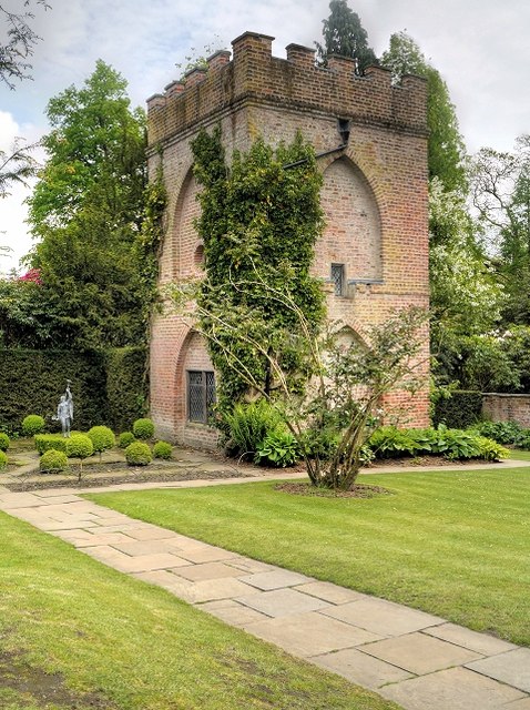
Tradition says that its original purpose was to watch for sheep stealing in the park although it seems too elaborate for such a use. There was quite a fashion for cold baths from the mid-18th century, usually set at a distance from the house and the building may have combined this function with that of prospect tower, the upper storey containing rainwater tanks.
It is said that in later years, it was not unusual for this tower to house a hermit whose role was to frighten house guests as they enjoyed the garden in the evening.
Link
Tatton Park Gardens lie immediately to the south of Tatton Hall Link , and consist of formal and informal gardens within Tatton Park Link . Included in the gardens are an Italian garden, a walled garden, a rose garden and the Japanese garden. The buildings in the garden are the Conservatory, the Fernery and the Showhouse. The gardens are owned by the National Trust and administered by Cheshire East Council.
The gardens are registered under the Historic Buildings and Ancient Monuments Act 1953 within the Register of Historic Parks and Gardens by English Heritage, designated at Grade II* for special historic interest(LinkNational Heritage List for England). They are open to the public at advertised times (Link
 Map © Crown Copyright")
- Grid Square
- SJ7481, 239 images (more nearby 🔍)
- Photographer
- David Dixon (more nearby)
- Date Taken
- Thursday, 15 May, 2014 (more nearby)
- Submitted
- Monday, 19 May, 2014
- Subject Location
-
OSGB36:
 SJ 7434 8136 [10m precision]
WGS84: 53:19.7117N 2:23.2043W - Camera Location
-
OSGB36: SJ 7434 8138
- View Direction
- SOUTH (about 180 degrees)