2014
NS5679 : Strathblane Parish Kirkyard: standing stone
taken 10 years ago, near to Strathblane, Stirling, Scotland
This is 1 of 5 images, with title starting with Strathblane Parish in this square
Strathblane Parish Kirkyard: standing stone
For more on the church itself, see NS5679 : Strathblane Parish Church.
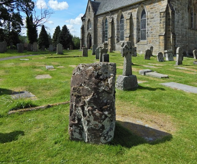
In the foreground of the present picture is the standing stone that is marked on the 1:25000 map. As described in the book "Archaeology Around Glasgow" (Susan Hothersall, 2007), it is "a single five-sided stone, just over 1m high. This may just be the last remnant of a huge mound which was destroyed before 1793. A series of cists were found within the mound, each containing a burial urn and each marked by a pentangular stone. The stones of this mound were built into the eighteenth-century churchyard wall".
In the foreground of the present picture is the standing stone that is marked on the 1:25000 map. As described in the book "Archaeology Around Glasgow" (Susan Hothersall, 2007), it is "a single five-sided stone, just over 1m high. This may just be the last remnant of a huge mound which was destroyed before 1793. A series of cists were found within the mound, each containing a burial urn and each marked by a pentangular stone. The stones of this mound were built into the eighteenth-century churchyard wall".
Strathblane Parish Church
The church, by architect John Brash, was ready for use at the start of 1804. It replaced an early-eighteenth-century church, itself the successor of an earlier building. Chapter VIII of J G Smith's "The Parish of Strathblane" (1886) gives more details, and Appendix I of the same work gives a complete listing of the memorial inscriptions that were to be seen in the kirkyard at that time.
 Map © Crown Copyright")
TIP: Click the map for more Large scale mapping
- Grid Square
- NS5679, 125 images (more nearby 🔍)
- Photographer
- Lairich Rig (more nearby)
- Date Taken
- Friday, 20 June, 2014 (more nearby)
- Submitted
- Monday, 21 July, 2014
- Subject Location
-
OSGB36:
 NS 5638 7937 [10m precision]
WGS84: 55:59.1445N 4:18.2211W - Camera Location
-
OSGB36: NS 5639 7937
- View Direction
- West-northwest (about 292 degrees)