2014
SO5924 : East Tower, Wilton Castle
taken 10 years ago, near to Bridstow, County of Herefordshire, England
This is 1 of 2 images, with title East Tower, Wilton Castle in this square
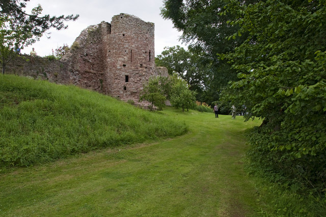
East Tower, Wilton Castle
View of the fourteenth century east tower from the dry moat.
Wilton Castle probably started as a timber motte and bailey castle. The ruins that are there today are mostly from the twelfth century castle, with fourteenth century towers, built from local red sandstone. The castle had an unremarkable history and by the sixteenth century its military significance had declined. A manor house was built using stone from other parts of the castle but this wasn't to stand for long. At the outbreak of the Civil War, the owner, Sir John Bridges, refused to declare for either side. Thus, on a Sunday morning in the spring of 1645, he returned home from church to find his house engulfed in flames. Sir John immediately declared for the parliamentarians.
In 1731 the estate was bought by the trustees of Guys Hospital, under their stewardship a new house was added and extended in the eighteenth century. They sold the estate in 1961. By then the castle was mostly forgotten despite the substantial ruins and standing close to the A40. Sue and Alan Parslow bought the castle in 2002 and in partnership with English Heritage have undertaken a comprehensive programme of restoration.
The Castle is currently open on Wednesday and Sunday afternoons, June to August. Along with selected other dates. Link (Archive Link )
Wilton Castle probably started as a timber motte and bailey castle. The ruins that are there today are mostly from the twelfth century castle, with fourteenth century towers, built from local red sandstone. The castle had an unremarkable history and by the sixteenth century its military significance had declined. A manor house was built using stone from other parts of the castle but this wasn't to stand for long. At the outbreak of the Civil War, the owner, Sir John Bridges, refused to declare for either side. Thus, on a Sunday morning in the spring of 1645, he returned home from church to find his house engulfed in flames. Sir John immediately declared for the parliamentarians.
In 1731 the estate was bought by the trustees of Guys Hospital, under their stewardship a new house was added and extended in the eighteenth century. They sold the estate in 1961. By then the castle was mostly forgotten despite the substantial ruins and standing close to the A40. Sue and Alan Parslow bought the castle in 2002 and in partnership with English Heritage have undertaken a comprehensive programme of restoration.
The Castle is currently open on Wednesday and Sunday afternoons, June to August. Along with selected other dates. Link
 Map © Crown Copyright")
TIP: Click the map for more Large scale mapping
- Grid Square
- SO5924, 1610 images (more nearby 🔍)
- Photographer
- Stuart Wilding (more nearby)
- Date Taken
- Sunday, 20 July, 2014 (more nearby)
- Submitted
- Saturday, 26 July, 2014
- Subject Location
-
OSGB36:
 SO 5904 2437 [10m precision]
WGS84: 51:54.9805N 2:35.8157W - Camera Location
-
OSGB36: SO 59053 24358
- View Direction
- North-northeast (about 22 degrees)