2014
TG2114 : The City of Norwich Aviation Museum (CNAM)
taken 10 years ago, near to Norwich Airport, Norfolk, England
This is 1 of 22 images, with title The City of Norwich Aviation Museum (CNAM) in this square
The City of Norwich Aviation Museum (CNAM)
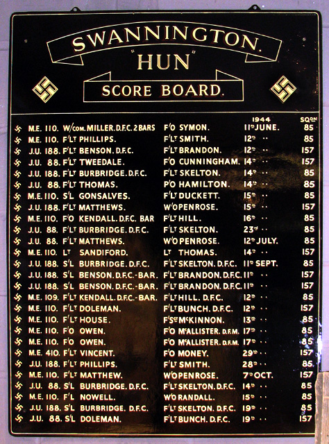
Depicted here is the score board of RAF Swannington (Haveringland), listing all the enemy aircraft shot down by squadron members based there during WW2. The board was rescued when the building that housed it was demolished and it can now be seen in the 100 Group Stafford Sinclair Memorial Room which is dedicated to the RAF 100 Group (Bomber Support), created in November 1943 and tasked with all electronic and radio counter-measures. The aerodromes involved were RAF Oulton, RAF North Creake (Egmere), RAF Foulsham, RAF Great Massingham, RAF Little Snoring, RAF West Raynham and RAF Swannington (Haveringland). The Group's headquarters was at Bylaugh Hall in the Breckland district of Norfolk.
The City of Norwich Aviation Museum (CNAM) was initially a project of a group of aviation enthusiasts associated with the Eastern Counties Omnibus Company in 1977. Membership was later opened to non-employees and by 1982 the museum had moved to its present site at Norwich International Airport > Link. The museum houses a great number of exhibits, including Boulton & Paul who were involved in the manufacture of aircraft from 1914 until 1961; RAF Bomber, Fighter and Coastal Command and the "special duties" RAF 100 Group; RAF Coltishall (closed a few years ago); the United States Army Air Forces' (USAAF) Eighth Air Force; Women in Aviation; WW1, and of course aircraft, uniforms, and many others. Link
The City of Norwich Aviation Museum (CNAM) was initially a project of a group of aviation enthusiasts associated with the Eastern Counties Omnibus Company in 1977. Membership was later opened to non-employees and by 1982 the museum had moved to its present site at Norwich International Airport > Link. The museum houses a great number of exhibits, including Boulton & Paul who were involved in the manufacture of aircraft from 1914 until 1961; RAF Bomber, Fighter and Coastal Command and the "special duties" RAF 100 Group; RAF Coltishall (closed a few years ago); the United States Army Air Forces' (USAAF) Eighth Air Force; Women in Aviation; WW1, and of course aircraft, uniforms, and many others. Link
RAF Swannington
The aerodrome at Swannington became operational in April 1944. It was the last airfield to be opened in Norfolk during the war. Locally known as Haveringland airfield, the station was the home of two RAF squadrons, the 85th and the 157th, and for some time also of No. 229 and 451 Squadrons of the Royal Australian Air Force. Put under RAF care and maintenance in August 1945 it was closed in 1947 and sold off in 1957. See also: Link
 Map © Crown Copyright")
TIP: Click the map for more Large scale mapping
- Grid Square
- TG2114, 69 images (more nearby 🔍)
- Photographer
- Evelyn Simak (more nearby)
- Date Taken
- Saturday, 23 August, 2014 (more nearby)
- Submitted
- Sunday, 24 August, 2014
- Subject Location
-
OSGB36:
 TG 2162 1409 [10m precision]
WGS84: 52:40.7493N 1:16.6207E - Camera Location
-
OSGB36: TG 2160 1409
- View Direction
- EAST (about 90 degrees)