SP9314 : High Water at The Twist (May 2014)
taken 10 years ago, near to Marsworth, Buckinghamshire, England
Half way along the Eastern road round the reserve there is a turning towards the Lake. Go down the slope and you get to a flat area with a number of paths leading off it.
Turn left and you get to the head of the northern track to the Octagon hide (flooded in 2014).
To the right there is a gated path which goes past the Woodell Hide.
Also to the right there is a track (closed to the public) which leads down to Juniper Valley and the Millennium Orchard.
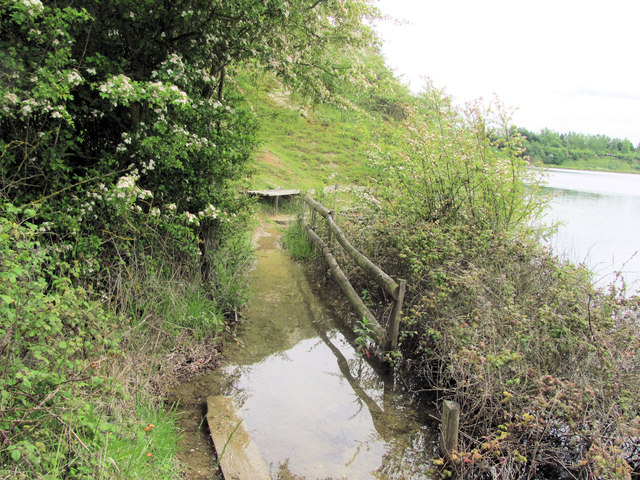
The Twist is the path by the wooden seat that zigzags its way down the cliff in front of you and now comes to a dead end.
In 1986, when the reserve was being planned the route via Juniper Valley lead to several bird hides overlooking a couple of island. Unfortunately the water rose far higher than was anticipated, covering the islands and the sites of the hides and closing off the bottom of Juniper Valley.
The Twist was constructed to provide an alternative way down the quarry face to connect with a lower level track which itself became flooded and it now ends at the water's edge.
College Lake is a large nature reserve with a very wide variety of habitats created from a large chalk pit. There is a large area of marsh with islands, and a deep water lake, while the cliffs surrounding the pit are in various stages of being "recovered" by nature. There is open meadow land and an area kept as an old fashioned cornfield full of flowers. There is woodland all round the area (originally planted to hide the quarry) and a large new woodland of native trees and shrubs. This all means that whatever time of the year you visit you can expect to see a wide variety of wildlife.
There are good facilities for the visitor (and for school parties), including many hides, and displays of old agricultural equipment. It is run by the Berks, Bucks & Oxon Wildlife Trust. Link
 Map © Crown Copyright")
- Grid Square
- SP9314, 195 images (more nearby 🔍)
- Photographer
- Chris Reynolds (more nearby)
- Date Taken
- Wednesday, 21 May, 2014 (more nearby)
- Submitted
- Sunday, 31 August, 2014
- Subject Location
-
OSGB36:
 SP 9331 1440 [10m precision]
WGS84: 51:49.2267N 0:38.8573W - Camera Location
-
OSGB36: SP 9330 1441
- View Direction
- South-southeast (about 157 degrees)