2014
TG2522 : The former Officers' Mess (east wing)
taken 10 years ago, near to Little Hautbois, Norfolk, England
This is 1 of 3 images, with title The former Officers' Mess (east wing) in this square
The former Officers' Mess (east wing)
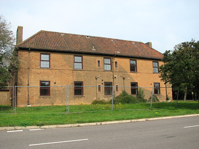
This is building no. 50, the former officers mess. It dates from the late 1930s and was built in a neo-Georgian style, typical of the care taken over the design of many permanent RAF airfields during that time. Traces of wartime camouflage are still adhering to its walls.
The building housing the officers' mess has stood empty since the airfield was closed in 2006 and most of the land and the buildings on it are currently owned by the North Norfolk County Council. Until the fate of these buildings has been decided they are surrounded by a high security fence and inaccessible to the public. The building is located on the north side of Jaguar Drive, the access road to HMP Bure.
The building housing the officers' mess has stood empty since the airfield was closed in 2006 and most of the land and the buildings on it are currently owned by the North Norfolk County Council. Until the fate of these buildings has been decided they are surrounded by a high security fence and inaccessible to the public. The building is located on the north side of Jaguar Drive, the access road to HMP Bure.
RAF Coltishall
The station opened in 1939 as a fighter airfield during WW2. It later became a station for night fighters and then for ground attack aircraft until it was closed in 2006. Coltishall was the last surviving operational RAF airfield involved in the Battle of Britain other than RAF Northolt. The station was home to more than 80 fighter squadrons during its time of operation and 207 enemy aircraft were destroyed during the war. The airfield is currently owned by Norfolk County Council, with most of the former domestic site now being occupied by HMP Bure. See also: Link
 Map © Crown Copyright")
TIP: Click the map for more Large scale mapping
- Grid Square
- TG2522, 28 images (more nearby 🔍)
- Photographer
- Evelyn Simak (more nearby)
- Date Taken
- Friday, 19 September, 2014 (more nearby)
- Submitted
- Friday, 19 September, 2014
- Subject Location
-
OSGB36:
 TG 2558 2297 [10m precision]
WGS84: 52:45.4328N 1:20.4946E - Camera Location
-
OSGB36: TG 2559 2296
- View Direction
- North-northwest (about 337 degrees)