TL9152 : Pillbox on the railway embankment
taken 10 years ago, near to Cockfield, Suffolk, England
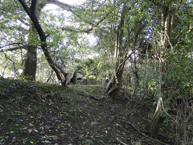
The 11 Corps Eastern Command Line (also known as the Corps Line) ran from Wivenhoe (Essex) to Mildenhall (Suffolk) and continued up to The Wash above Sutton Bridge. It consists of a continuous natural or artificial tank obstacle with numerous pillboxes and heavy artillery emplacements. Responsibility for the line from Wivenhoe to Wakes Colne Viaduct was 15th Div Royal Engineers. From Wakes Colne onwards the 11 Corps Royal Engineers were responsible. In Suffolk the line was divided in to three sectors, with a RE Field Company responsible for each sector.
The Field Companies (228, 229 and 230 ) were deployed to the area in July 1940 to start building the structures on the Corps Line. Work continued until September when the War Diaries note a slow down in work and by October no more pillboxes were to be built and only those already under construction were to be completed.
The pillboxes and heavy to medium artillery emplacements were constructed by civilian contractors, the siting of the pillboxes being determined by the Division based in the area. Once the site had been chosen RE Field Companies handed over the details to the contractors. Contractors were appointed by the Federation of Building Contractors through a District Leader and Group Contractor. The artificial tank obstacle was constructed by 135 Excavator Company, the line of the ditch being given by the RE Field Companies. Tank blocks (e.g. at railway station yards) were to be 5 ft concrete blocks at 3 ft 6 in spacing. Small streams and parts of the River Lark were also dammed in places to enhance the obstacle. Road blocks were constructed by County Councils under the supervision of the Divisional Road Engineer of the Ministry of Transport. Direct labour (some unpaid volunteers) was employed in clearing fields of fire, tree felling and trimming up the anti-tank ditch. Three designs of pillboxes were specified for the line but there are many variants and some built especially for the environment into which they were placed.
 Map © Crown Copyright")
- Grid Square
- TL9152, 15 images (more nearby 🔍)
- Photographer
- Adrian S Pye (more nearby)
- Date Taken
- Tuesday, 7 October, 2014 (more nearby)
- Submitted
- Tuesday, 7 October, 2014
- Subject Location
-
OSGB36:
 TL 91271 52828 [1m precision]
WGS84: 52:8.4374N 0:47.6217E - Camera Location
-
OSGB36: TL 9127 5281
- View Direction
- Northwest (about 315 degrees)