2014
TQ3702 : Connor's Court, Rottingdean
taken 9 years ago, near to Rottingdean, Brighton And Hove, England
This is 1 of 2 images, with title Connor's Court, Rottingdean in this square
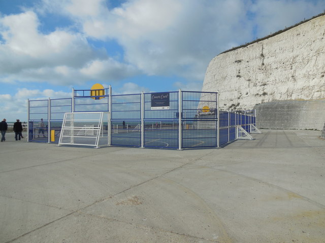
Connor's Court, Rottingdean
Community Court on the site of the former Rottingdean Swimming Pool opened in October 2014
The court offers a fenced area with proper court markings and goals for 5 a side football, basketball, mini football and cricket bowling and batting practice. The surface is polymeric which is a product often used for tennis courts and athletics tracks and which offers a more forgiving and flexible surface than tarmac or concrete
The court has been created in memory of 19 year old Connor Saunders who died in Rottingdean in April 2012 and is intended to offer young people a better alternative to just hanging around with nothing to do. Link
Undercliff walk - Brighton
In 1928, Rottingdean parish was absorbed by Brighton and in order to protect the coastline an impressive sea wall at the base of the cliffs was erected, initially from Black Rock (the former boundary of Brighton parish) to Rottingdean.
The Undercliff Walk, as it became known, was designed by borough engineer David Edwards and opened in July 1933. It was extended to Saltdean Gap in July 1935 when the Rottingdean swimming-pool was built to replace bathing facilities lost to the wall.
A final short addition to the wall taking it to the very end of the borough boundary was made later in 1935. The Undercliff Walk is now 3.35 miles long and forms part of a 7.5 mile promenade from Portslade to Saltdean. Link
 Map © Crown Copyright")
TIP: Click the map for more Large scale mapping
- Grid Square
- TQ3702, 136 images (more nearby 🔍)
- Photographer
- Paul Gillett (more nearby)
- Date Taken
- Tuesday, 28 October, 2014 (more nearby)
- Submitted
- Tuesday, 28 October, 2014
- Subject Location
-
OSGB36:
 TQ 37211 02036 [1m precision]
WGS84: 50:48.0988N 0:3.2532W - Camera Location
-
OSGB36: TQ 37238 02041
- View Direction
- WEST (about 270 degrees)