2007
TL7278 : Eriswell village sign
taken 17 years ago, near to Eriswell, Suffolk, England
This is 1 of 3 images, with title Eriswell village sign in this square
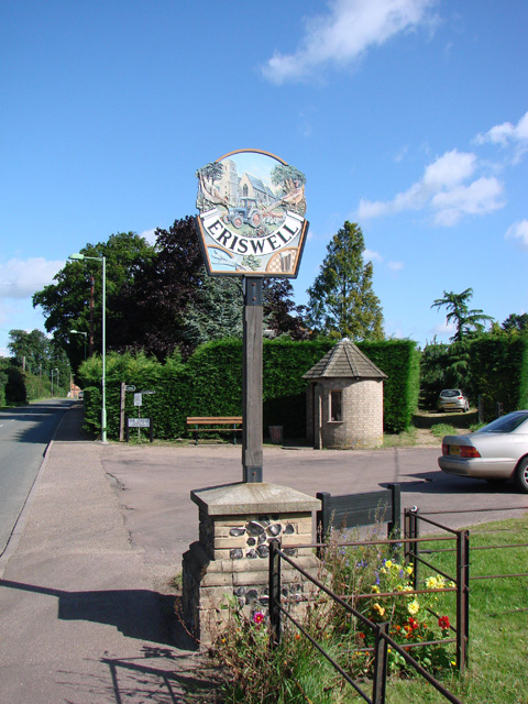
Eriswell village sign
The sign has Eriswell church of St Peter as a background to a tractor and plough which symbolises the agricultural heritage of the parish. On the left is a stone curlew with pine trees, and on the right a cock pheasant with wheat, representing the nature of the warrens and heathland to the east. Below the name is an jet aircraft of the USAF representative of neighbouring Lakenheath, a twig of oak leaves and acorns and a glass of beer with a chequered background illustrating the fact The Chequers public house is only a stones throw away.
Link
Link
Village Signs of East Anglia
Village signs are typically placed along the principal road or in a prominent location such as a village green or close by the church. The design often depicts a particularly feature of the village or a scene from its history, heritage, or culture. They are typically made of wood or metal or a combination of both, the designs are often made by the local community.
Although they do appear in villages and towns all over the country they are more prominent in East Anglia than elsewhere in the country.
 Map © Crown Copyright")
TIP: Click the map for more Large scale mapping
- Grid Square
- TL7278, 15 images (more nearby 🔍)
- Photographer
- Adrian S Pye (more nearby)
- Date Taken
- Saturday, 28 July, 2007 (more nearby)
- Submitted
- Saturday, 27 December, 2014
- Subject Location
-
OSGB36:
 TL 72272 78186 [1m precision]
WGS84: 52:22.4775N 0:31.7576E - Camera Location
-
OSGB36: TL 7226 7820
- View Direction
- South-southeast (about 157 degrees)