1968
NT2674 : The Calton Hill from Mutrie's Hill
taken 56 years ago, near to Edinburgh, Scotland
The Calton Hill from Mutrie's Hill
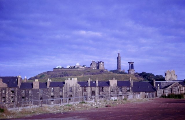
I've used the historical name for the space here once occupied by St. James' Square, a later eastern extension of the New Town. Its rather run-down tenements were cleared in the late 1960s to make way for a new shopping and hotel complex, to which a massive block of government offices was later added. Appeals to save the square and renovate the tenements fell on deaf ears. Perhaps this was in some way connected with the fact that the hotel proprietors, Scottish Brewers Ltd., happened to be Edinburgh's biggest employer at the time. But time has moved on and plans for the area's next re-development look much more imaginative and exciting. This photo, from the Spring of 1968, shows the Calton Hill and its monuments rising above tenements awaiting demolition on the west side of Leith Street. It meant bidding farewell to a long upper-level Victorian Terrace walkway the length of the street ending at the entrance to the 'Top Storey' club.
For the historical significance of Mutrie's Hill, see Link
For the area's next redevelopment as of 2015, see Link (Archive Link )
For the historical significance of Mutrie's Hill, see Link
For the area's next redevelopment as of 2015, see Link
 Map © Crown Copyright")
TIP: Click the map for more Large scale mapping
- Grid Square
- NT2674, 1182 images (more nearby 🔍)
- Photographer
- kim traynor (more nearby)
- Date Taken
- March 1968 (more nearby)
- Submitted
- Friday, 2 January, 2015
- Subject Location
-
OSGB36:
 NT 2609 7416 [10m precision]
WGS84: 55:57.2854N 3:11.1154W - Camera Location
-
OSGB36: NT 2593 7418
- View Direction
- EAST (about 90 degrees)