2015
SN0218 : The Modern Way In
taken 9 years ago, near to Wiston, Pembrokeshire/Sir Benfro, Wales
The Modern Way In
William the Conquerors second son Henry 1st decided soon after his coronation in 1100 to strengthen his hold on Wales by introducing Flemings from the inundated low countries to Pembrokeshire to subdue the warring Welsh. The Flemings had a reputation as good soldiers, enterprising farmers and skilled craftsmen, whom Henry believed could colonise and govern his new territory, leaving him to control the rest of the kingdom.
The Flemish chieftain was a fierce warrior called Wizo, who decided to occupy the fertile farmland in the area known as Roose or Rhos, and he chose Wiston as the site for his motte-and bailey HQ, Wizos Tun. It was in all probability already the site of an Iron Age rath or enclosed settlement. By 1112 he had established Wiston as a Borough, with all the privileges that status brought with it, including a Royal Charter to hold an annual fair and a weekly market. He and his followers built a village in the typical linear style of a Norman settlement, and this remains the ribbon form of Wiston to this day.
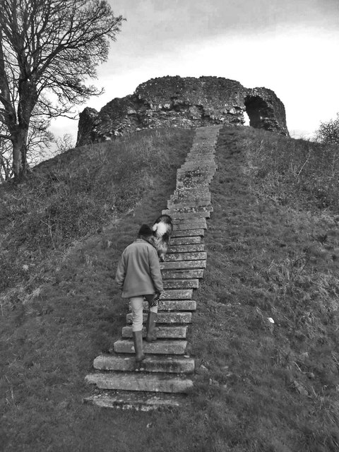
The early 12th century motte-and-bailey structure, which would have been a wooden pallisaded enclosure on the top of a defensive mound, which is still visible from the road, and is described by antiquarians as the best example of a motte-and-bailey castle in South-West Wales, was replaced in the 13th century by a stone keep. It had in the meantime been attacked several times by the Welsh who resented the intrustion of these foreign troops on their soil, right on the notional Landsker line separating the occupied territory from the Welshery to the north and east. The Welsh captured Wizos Tun in 1147 and 1193, before Llywelyn the Great destroyed it and burnt the town in 1220. Henry III ordered the rebuilding of the castle before 1231, and this is when the sturdy stone keep was erected. Today visitors to the site will see a large bailey and a high motte surrounded by a deep dry ditch and crowned with the remains of a polygonal shell keep. Access is through a simple arched doorway on the southern side and the remains of a flight of stone steps inside suggest that the keep was originally a building of at least two storeys. It appears that there was a third phase of later construction to thicken the walls.The unusually large bailey south of the motte is defended by an earth bank and ditch and the remains of medieval buildings lie under the turf. Access to the bailey would have been via the eastern entrance.
The castle and manor house were owned by the Wogan family of Picton Castle by 1324 and acquired by the Cawdors in 1794
The Flemish chieftain was a fierce warrior called Wizo, who decided to occupy the fertile farmland in the area known as Roose or Rhos, and he chose Wiston as the site for his motte-and bailey HQ, Wizos Tun. It was in all probability already the site of an Iron Age rath or enclosed settlement. By 1112 he had established Wiston as a Borough, with all the privileges that status brought with it, including a Royal Charter to hold an annual fair and a weekly market. He and his followers built a village in the typical linear style of a Norman settlement, and this remains the ribbon form of Wiston to this day.
The early 12th century motte-and-bailey structure, which would have been a wooden pallisaded enclosure on the top of a defensive mound, which is still visible from the road, and is described by antiquarians as the best example of a motte-and-bailey castle in South-West Wales, was replaced in the 13th century by a stone keep. It had in the meantime been attacked several times by the Welsh who resented the intrustion of these foreign troops on their soil, right on the notional Landsker line separating the occupied territory from the Welshery to the north and east. The Welsh captured Wizos Tun in 1147 and 1193, before Llywelyn the Great destroyed it and burnt the town in 1220. Henry III ordered the rebuilding of the castle before 1231, and this is when the sturdy stone keep was erected. Today visitors to the site will see a large bailey and a high motte surrounded by a deep dry ditch and crowned with the remains of a polygonal shell keep. Access is through a simple arched doorway on the southern side and the remains of a flight of stone steps inside suggest that the keep was originally a building of at least two storeys. It appears that there was a third phase of later construction to thicken the walls.The unusually large bailey south of the motte is defended by an earth bank and ditch and the remains of medieval buildings lie under the turf. Access to the bailey would have been via the eastern entrance.
The castle and manor house were owned by the Wogan family of Picton Castle by 1324 and acquired by the Cawdors in 1794
 Map © Crown Copyright")
TIP: Click the map for more Large scale mapping
- Grid Square
- SN0218, 81 images (more nearby 🔍)
- Photographer
- Deborah Tilley (more nearby)
- Date Taken
- Saturday, 17 January, 2015 (more nearby)
- Submitted
- Saturday, 17 January, 2015
- Subject Location
-
OSGB36:
 SN 0225 1816 [10m precision]
WGS84: 51:49.6180N 4:52.2650W - Camera Location
-
OSGB36: SN 0225 1817
- View Direction
- North-northeast (about 22 degrees)