2015
TQ5446 : Brass, St Mary's church, Leigh
taken 9 years ago, near to Leigh, Kent, England
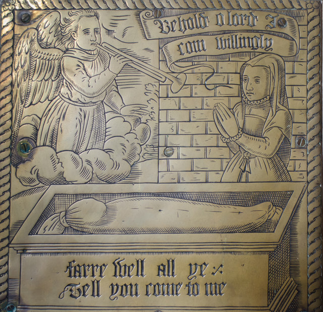
Brass, St Mary's church, Leigh
Re-sited from the chancel. Circa 1580.
St Mary's church, Leigh
Grade II* listed.
The church consists of a west tower of four stages dating from the 15th century, although only 9 feet of the tower was originally built and a timber Belfry was erected. It was finished in the 19th century. There is a 13th century tower arch, and a separate turret with spiral staircase. The tower has six bells.
There was originally a gallery in the tower which was removed in the 19th century.
The nave has a three bay arcade to the south aisle, the north wall dates from the early 16th century following a fire in which the north aisle was destroyed. The remains of a 13th century pillar can still be seen with the original red stencilling.
The chancel has a 14th century three Bay arcade to the south Chapel which now contains the organ from 1879.
The church was restored in 1860 when a turret was added to the chancel, and circa 1890 when the chancel was remodelled.
The church contains several Ledger stones and a brass inscription which dates from 1407. On the north wall there is a brass from C.1580 showing an open coffin and Angel blowing a trumpet.
There is an octagonal perpendicular font with floral motifs and grotesque masks. The pulpit dates from the 17th century.
Most of the stained glass is 19th C.
Image classification
(about):
Supplemental image
This page has been
viewed about
82 times
 Map © Crown Copyright")
 TQ 5488 4662 [10m precision]