SK3536 : Derby - The Strand - convergence with The Wardwick
taken 9 years ago, near to Derby, England
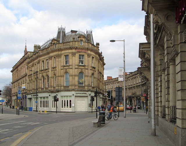
The Strand is a short street in Derby city centre and contains an elegant curved terrace of shops and offices.
Unlike much of Derby city centre, The Strand is not part of the medieval street pattern, but owes its existence to the late nineteenth century culverting of the Markeaton Brook. Markeaton Brook was culverted in stages, with what is now Albert Street and Victoria Street being culverted in the 1830's and the part along the line of The Strand being done in 1877/8.
The curved terrace of shops and offices (Nos 2 to 40) on the north side of The Strand was designed by J. S. Storey and completed in 1881. This terrace and associated The Strand Arcade was a commercial venture by the then-mayor of Derby, Sir Abraham Woodwiss.
The terrace and the entrances to the Arcade are grade II listed by English Heritage (see Link).
The street itself forms part of the City Centre Conservation Area (see Link
* It is a fine nineteenth century street lined with grand stone classical buildings.
* It is a particularly well-designed set piece of neoclassical architecture with ornate stone pilasters and delicate proportions.
* Its classical style, ashlar stonework and repetition of features gives an architecturally-unified terrace.
* The Strand Arcade is a fine example of a late nineteenth century arcade in stone, iron and glass.
The Strand extends about 200 yards between its junctions with Cheapside, Bold Lane and Sadler Gate in the NW and The Wardwick, St James Street and Victoria Street in the SE. The Strand Arcade runs about 50 yards between The Strand in the S and Sadler Gate in the N.
 Map © Crown Copyright")
- Grid Square
- SK3536, 1176 images (more nearby 🔍)
- Photographer
- Dave Bevis (more nearby)
- Date Taken
- Friday, 6 March, 2015 (more nearby)
- Submitted
- Monday, 9 March, 2015
- Subject Location
-
OSGB36:
 SK 3513 3622 [10m precision]
WGS84: 52:55.3351N 1:28.7359W - Camera Location
-
OSGB36: SK 3515 3620
- View Direction
- Northwest (about 315 degrees)