2015
TQ3188 : Harringay Green Lanes station
taken 9 years ago, near to Hornsey, Haringey, England
This is 1 of 11 images, with title Harringay Green Lanes station in this square
Harringay Green Lanes station
The Tottenham & Hampstead Junction Railway was planned to run from Tottenham Hale on the Great Eastern Railway to Gospel Oak on the Hampstead Junction section of the London & North Western Railway. It was worked by the North London Railway (NLR) from its opening in 1860, and in 1864 came under NLR control. On 21st July 1868 a new line opened from Tottenham Hale to Highgate Road. It was only in 1887 that an extension to Gospel Oak was achieved but as a passenger exchange not as a junction.
On 9th July 1894, the Tottenham & Forest Gate Railway was opened for through goods and passenger trains and had stations at Blackhorse Road, Walthamstow, Leyton, Leytonstone and Wanstead Park. Up to 1912 the line was a joint railway operated by the Midland Railway and the London, Tilbury & Southend Railway but from 1912 it was solely operated by the Midland. With the opening of the new line the Midland extended some of its South Tottenham trains to East Ham.
The line which now ran between Kentish Town and Barking was considered for closure to passengers in 1963 as part of the Beeching Axe, but it remained open. Even so, it was allowed to fall into a poor state of repair and reliability, and by 1980 had been cut back to an hourly service between Kentish Town and Barking. The station canopies were gradually demolished, ticket offices closed and staff withdrawn from stations.
The situation began to improve from 1981 when a new link to Gospel Oak was built and the hourly service from Kentish Town to Barking was replaced by the present route from Gospel Oak to Barking with two trains per hour. Now with it being taken over by Transport for London as part of the London Overground network the whole line has a new lease of life and new trains run every 15 minutes between Barking and Gospel Oak.
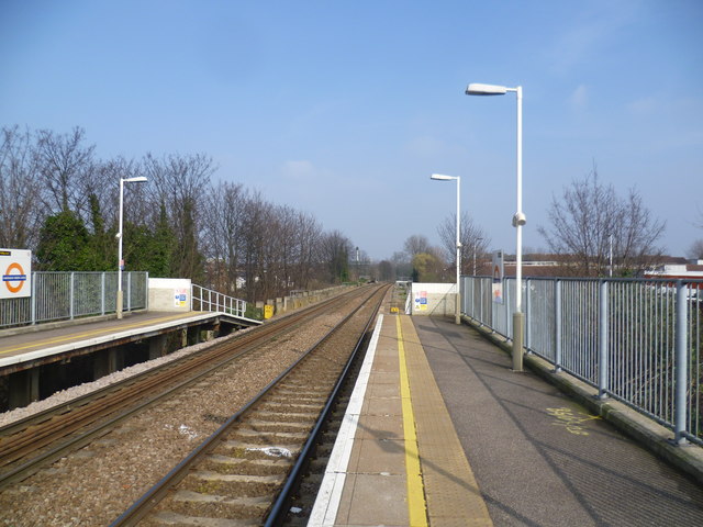
Harringay Green Lanes station was opened on 1st June 1880 as 'Green Lanes'. In 1883 it was renamed 'Harringay Park, Green Lanes' which it retained until 1951 when it became 'Harringay Park'. This changed again in 1958 to 'Harringay Stadium', then in 1990 it became 'Harringay East' which name lasted for just over a year before being given its current name on 8th July 1991.
The next station in this direction is South Tottenham, although St Ann's Road station was closer but this closed in 1942.
On 9th July 1894, the Tottenham & Forest Gate Railway was opened for through goods and passenger trains and had stations at Blackhorse Road, Walthamstow, Leyton, Leytonstone and Wanstead Park. Up to 1912 the line was a joint railway operated by the Midland Railway and the London, Tilbury & Southend Railway but from 1912 it was solely operated by the Midland. With the opening of the new line the Midland extended some of its South Tottenham trains to East Ham.
The line which now ran between Kentish Town and Barking was considered for closure to passengers in 1963 as part of the Beeching Axe, but it remained open. Even so, it was allowed to fall into a poor state of repair and reliability, and by 1980 had been cut back to an hourly service between Kentish Town and Barking. The station canopies were gradually demolished, ticket offices closed and staff withdrawn from stations.
The situation began to improve from 1981 when a new link to Gospel Oak was built and the hourly service from Kentish Town to Barking was replaced by the present route from Gospel Oak to Barking with two trains per hour. Now with it being taken over by Transport for London as part of the London Overground network the whole line has a new lease of life and new trains run every 15 minutes between Barking and Gospel Oak.
Harringay Green Lanes station was opened on 1st June 1880 as 'Green Lanes'. In 1883 it was renamed 'Harringay Park, Green Lanes' which it retained until 1951 when it became 'Harringay Park'. This changed again in 1958 to 'Harringay Stadium', then in 1990 it became 'Harringay East' which name lasted for just over a year before being given its current name on 8th July 1991.
The next station in this direction is South Tottenham, although St Ann's Road station was closer but this closed in 1942.
 Map © Crown Copyright")
TIP: Click the map for more Large scale mapping
- Grid Square
- TQ3188, 367 images (more nearby 🔍)
- Photographer
- Marathon (more nearby)
- Date Taken
- Wednesday, 18 March, 2015 (more nearby)
- Submitted
- Thursday, 19 March, 2015
- Subject Location
-
OSGB36:
 TQ 3195 8822 [10m precision]
WGS84: 51:34.6445N 0:5.8318W - Camera Location
-
OSGB36: TQ 3192 8820
- View Direction
- East-northeast (about 67 degrees)