2008
SS6387 : Mumbles Pier and Lifeboat Station
taken 16 years ago, near to Mumbles, Swansea/Abertawe, Wales
This is 1 of 3 images, with title Mumbles Pier and Lifeboat Station in this square
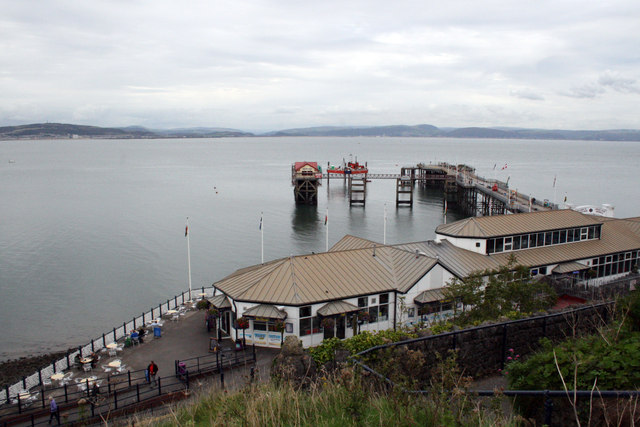
Mumbles Pier and Lifeboat Station
The lifeboat station accessed from the pier couldn't house the larger Mumbles RNLI £2.7m Tamar class boat so a new station was to be built off-shore. The drilling rig seen just off the pier is testing various parts of the seabed to identify suitable locations for the new station. The boat house dates from 1922 and is known to have been added to a pre-existing slipway, constructed during World War One about 1916. The new £9.5m Mumbles Lifeboat boathouse sited at the head of the Pier was officially opened on 14th march 2014. The modification to the pier and construction of the boat house was carried out by BAM Nuttall Ltd. for the RNLI in partnership with the pier owners AMECO Ltd.
Mumbles pier including the lifeboat station is Grade II Listed. Built in 1892-8 by W Sutcliffe Marsh, engineer and Mayoh and Haley, contractors, it was opened on 10 May 1898. A new landing stage was added in 1956 after the pier was breached during World War II. The Llanelly Railway proposed a pier in 1865 but it was not built. The existing pier was promoted by Sir John Jones Jenkins of the Rhondda and Swansea Bay Railway.
Mumbles pier including the lifeboat station is Grade II Listed. Built in 1892-8 by W Sutcliffe Marsh, engineer and Mayoh and Haley, contractors, it was opened on 10 May 1898. A new landing stage was added in 1956 after the pier was breached during World War II. The Llanelly Railway proposed a pier in 1865 but it was not built. The existing pier was promoted by Sir John Jones Jenkins of the Rhondda and Swansea Bay Railway.
 Map © Crown Copyright")
TIP: Click the map for more Large scale mapping
- Grid Square
- SS6387, 165 images (more nearby 🔍)
- Photographer
- Jo and Steve Turner (more nearby)
- Date Taken
- Monday, 8 September, 2008 (more nearby)
- Submitted
- Saturday, 21 March, 2015
- Subject Location
-
OSGB36:
 SS 63219 87517 [1m precision]
WGS84: 51:34.1931N 3:58.4995W - Camera Location
-
OSGB36: SS 62990 87403
- View Direction
- East-northeast (about 67 degrees)