2015
SN7687 : The point where the water board track joins the Maesnant road
taken 9 years ago, near to Drosgol [hill or Mountain], Ceredigion, Great Britain
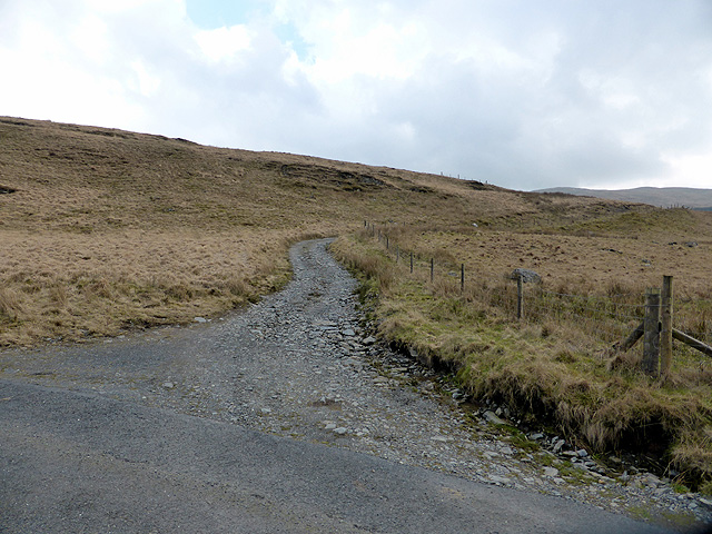
The point where the water board track joins the Maesnant road
I have lost count of the number of times that I have climbed Plynlimon but this was the first in 2015. A previous attempt, in February, had to be abandoned because of treacherous walking conditions on the frozen ground (see SN7886 : Plynlimon viewed from the Maesnant path). At 2467 feet it is a true mountain, the highest point in Mid-Wales and which affords excellent views over the Cambrian Mountains.
My preferred route is the path which follows Maesnant on the west side of the mountain. Most of the path is unmarked by the OS, even on the 25k map, but the route is self-evident on the ground. Several other routes are available but probably the most popular is that from Eisteddfa Gurig starting at GR SN79798407 (parking charges apply). That route is graded 'hard' by 'Walking Britain' but in my opinion it provides a gentler ascent than does the Maesnant route.
The Maesnant Route
Starting at the cattle grid beside Nant-y-moch reservoir at GR SN76818738, where parking for two three cars is available, the actual walking distance to the summit is only just under two miles. Initially the route follows the water board track which provides vehicular access to Llyn Llygad Rheidol Reservoir which lies in the lee of the north slope of Plynlimon. The track is very rough in places and is definitely not suitable for family saloons but there appears to be no restriction if one should decide to take a four-wheeled drive along it.
After about ¾ of a mile, the track crosses Maesnant GR SN77748765 and it is here that the route to the summit diverges to the right and becomes a grassy path. A small flume is passed on the right, again, not marked by the OS, and the path starts to rise across some (usually) boggy ground. It continues east for another ¾ of a mile or so, skirting Pumlumon Fach to GR SN78938731. At this point the path ascends steeply towards the summit but a recommended diversion for a view over Llyn Llygad Rheidol, which is not visible from the summit of Plynlimon, is to the viewpoint at about SN79488711 (see SN7987 : Llyn Llygad Rheidol). The path then heads directly south for the short but steep final ascent to Plynlimon. I must say that it is a considerable relief when the summit trig point finally comes into view!
See other images of The ascent of Plynlimon (Pen Pumlumen Fawr)- March 2015
 Map © Crown Copyright")
TIP: Click the map for more Large scale mapping
- Grid Square
- SN7687, 123 images (more nearby 🔍)
- Photographer
- John Lucas (more nearby)
- Date Taken
- Tuesday, 17 March, 2015 (more nearby)
- Submitted
- Sunday, 22 March, 2015
- Subject Location
-
OSGB36:
 SN 7684 8737 [10m precision]
WGS84: 52:28.2198N 3:48.8717W - Camera Location
-
OSGB36: SN 76819 87403
- View Direction
- Southeast (about 135 degrees)