2012
SN7266 : The Bont Mural in Pontrhydfendigaid, Ceredigion
taken 12 years ago, near to Pontrhydfendigaid, Ceredigion/Sir Ceredigion, Wales
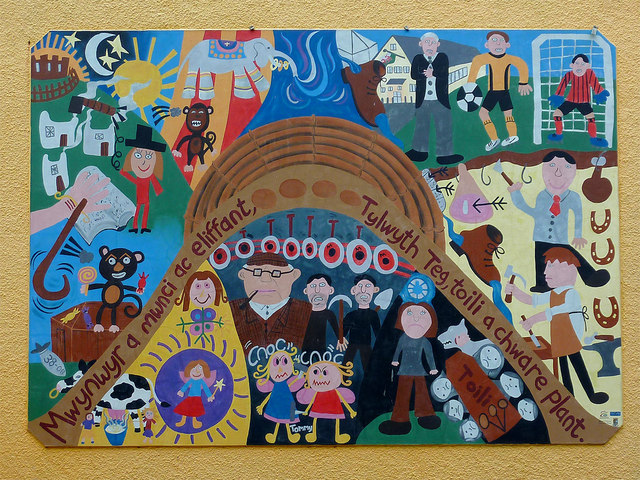
The Bont Mural in Pontrhydfendigaid, Ceredigion
This excellent piece of work is on the side of the corner cottage where Lisburne Road meets Bridge Street.
The text taken from the Spirit of the Miners (Ysbryd y Mwynwyr) website:
Link (Archive Link )
The bont mural project has involved the local children in Pontrhydfendigaid collecting stories relating to the heritage of their own community. The project has included holding storytelling community evenings which were held in the village hall and two local storytellers Charles Arch and Lyn Ebenezer visiting the school to tell the stories with the aim of the project being to strengthen and share local knowledge for future generations.
A mural was then created by the children to depict these stories which can be seen on the wall of a house in the centre of the village of Pontrhydfendigaid. The project has provided an opportunity to raise awareness of the history, traditions and heritage of the mining industry as well as other elements of culture and heritage of the area and has been recorded on a DVD.
SN7266 : Corner house with mural, Pontrhydfendigaid, Ceredigion
The text taken from the Spirit of the Miners (Ysbryd y Mwynwyr) website:
Link
The bont mural project has involved the local children in Pontrhydfendigaid collecting stories relating to the heritage of their own community. The project has included holding storytelling community evenings which were held in the village hall and two local storytellers Charles Arch and Lyn Ebenezer visiting the school to tell the stories with the aim of the project being to strengthen and share local knowledge for future generations.
A mural was then created by the children to depict these stories which can be seen on the wall of a house in the centre of the village of Pontrhydfendigaid. The project has provided an opportunity to raise awareness of the history, traditions and heritage of the mining industry as well as other elements of culture and heritage of the area and has been recorded on a DVD.
SN7266 : Corner house with mural, Pontrhydfendigaid, Ceredigion
 Map © Crown Copyright")
TIP: Click the map for more Large scale mapping
- Grid Square
- SN7266, 26 images (more nearby 🔍)
- Photographer
- Roger D Kidd (more nearby)
- Date Taken
- Tuesday, 24 April, 2012 (more nearby)
- Submitted
- Sunday, 22 March, 2015
- Subject Location
-
OSGB36:
 SN 7298 6642 [10m precision]
WGS84: 52:16.8721N 3:51.8027W - Camera Location
-
OSGB36: SN 7297 6641
- View Direction
- Northeast (about 45 degrees)