2015
SP9012 : Upper Farm and old barn, Drayton Beauchamp
taken 9 years ago, near to Wilstone, Hertfordshire, England
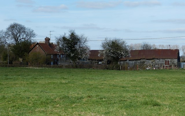
Upper Farm and old barn, Drayton Beauchamp
A view from the footpath across the field to the north of the church in Drayton Beauchamp looking across at Upper Farm and its much-photographed steadily collapsing barn (see (from 2005) SP9012 : Dilapidated farm building, Drayton Beauchamp, (2009) SP9012 : Derelict Old Barn, Upper Farm, Drayton Beauchamp, SP9012 : Gable End of Derelict Farm Barn, SP9012 : Broken Weather Boarding on Derelict Farm Barn, SP9012 : Collapsed end of Derelict Farm Barn, (2011) SP9012 : Old Barn at Upper Farm Drayton Beauchamp & (2014) SP9012 : Barn in poor condition)
The footpath this was taken from is the GUC LDP (see SP9012 : GUC Walk LDP near Drayton Beauchamp for explanation and SP9012 : Footpath across field, Drayton Beauchamp for a view of the path).
The footpath this was taken from is the GUC LDP (see SP9012 : GUC Walk LDP near Drayton Beauchamp for explanation and SP9012 : Footpath across field, Drayton Beauchamp for a view of the path).
 Map © Crown Copyright")
TIP: Click the map for more Large scale mapping
- Grid Square
- SP9012, 103 images (more nearby 🔍)
- Photographer
- Rob Farrow (more nearby)
- Date Taken
- Sunday, 22 March, 2015 (more nearby)
- Submitted
- Tuesday, 24 March, 2015
- Subject Location
-
OSGB36:
 SP 9014 1220 [10m precision]
WGS84: 51:48.0714N 0:41.6503W - Camera Location
-
OSGB36: SP 9009 1213
- View Direction
- Northeast (about 45 degrees)