2015
NS4477 : The summit of Doughnot Hill
taken 9 years ago, 3 km from Milton, West Dunbartonshire, Scotland
This is 1 of 2 images, with title The summit of Doughnot Hill in this square
The summit of Doughnot Hill
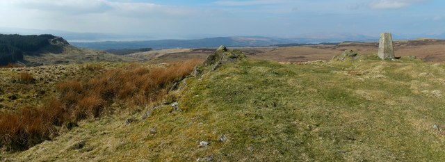
This is a wide-angle view (about 120°). The details in the foreground are those that are shown from a little further back in NS4477 : Doughnot Hill.
In the present view, Meikle White Hill (NS44347863; see Link for views) is at the far right, to the right of the trig point. Little White Hill (NS43987824) is directly behind the trig point. The wooded summit of Pappert Hill (NS42388017) is directly behind the little outcrop that is to the left of the trig point. Part of Loch Lomond can be seen beyond that.
Behind the pointed outcrop near the centre of the picture, and in darkness, are Carman Hill (NS3779) and adjacent muirs. A nearer area of woodland further to the left is Black Wood (NS42777734). Still nearer, the wooded area at the far left is at NS440772.
Doughnot Hill
Like many other hills in the area, this originated as a volcanic vent. An igneous dyke runs SWNE through the hill's north-western slopes. There is a trig point (S5142) on the summit. The name Doughnot Hill is given on OS maps from the first edition (1860) onwards. It also appears, with the same spelling, on the even earlier "Plan of Dumbarton Muir" (undated, but made in the early nineteenth century). It is likely that the name was originally pronounced [ˈdɔxnət] or similar. The Doughnot Burn winds anticlockwise around the northern side of the hill before flowing into the Overtoun Burn.
 Map © Crown Copyright")
TIP: Click the map for more Large scale mapping
- Grid Square
- NS4477, 79 images (more nearby 🔍)
- Photographer
- Lairich Rig (more nearby)
- Date Taken
- Friday, 10 April, 2015 (more nearby)
- Submitted
- Tuesday, 28 April, 2015
- Subject Location
-
OSGB36:
 NS 4469 7766 [10m precision]
WGS84: 55:58.0050N 4:29.3932W - Camera Location
-
OSGB36: NS 4473 7764
- View Direction
- West-northwest (about 292 degrees)