SK6821 : Church of St John the Baptist, Grimston
taken 9 years ago, near to Grimston, Leicestershire, England
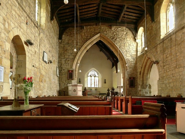
The church now consists simply of nave and chancel with south transept, west tower and south porch. The north transept collapsed in around 1740 and was not rebuilt.
It is built largely in the local ironstone, and the present building dates essentially from the early 13th century, with rebuilding around 1400. Major restoration followed during 1867-8. Traces of an earlier, Saxon or Norman, building can however be seen in the north wall of the nave, and the font dates from this period too. There are two old corbels on the east wall of the chancel from this period incorporated into the Victorian rebuilding.
The tower, clerestory and nave roof all date from the rebuilding in Perpendicular style around 1400. The main tie beams of the nave roof retain their original carved bosses.
Apart from the font the only fitting inside the church of significant age is the clock mechanism. This dates from 1600 or slightly earlier and is noted by English Heritage as being a very early provincial example of an anchor escapement. When overhauled in 1984 the wooden framework was found to be seriously weakened by woodworm, but the decision was taken to retain original timber, even though the result is that the clock cannot be returned to working order as it will not withstand the load of the weights. It has instead been place on display in the nave. Although not visitable, the bell frame dates back to the building of the tower, although the oldest bell only dates from 1749.
The church is Listed Grade II*.
The churchyard contains a number of early slate gravestones from the late 17th/early 18th centuries, including several of the Belvoir Angel type, 2 of which are Listed Grade II. There is also a Listed Grade II churchyard cross from the edieval period.
Listed buildings and structures are officially designated as being of special architectural, historical or cultural significance. There are over half a million listed structures in the United Kingdom, covered by around 375,000 listings.
Listed status is more commonly associated with buildings or groups of buildings, however it can cover many other structures, including bridges, headstones, steps, ponds, monuments, walls, phone boxes, wrecks, parks, and heritage sites, and in more recent times a road crossing (Abbey Road) and graffiti art (Banksy 'Spy-booth') have been included.
In England and Wales there are three main listing designations;
Grade I (2.5%) - exceptional interest, sometimes considered to be internationally important.
Grade II* (5.5%) - particularly important buildings of more than special interest.
Grade II (92%) - nationally important and of special interest.
There are also locally listed structures (at the discretion of local authorities) using A, B and C designations.
In Scotland three classifications are also used but the criteria are different. There are around 47,500 Listed buildings.
Category A (8%)- generally equivalent to Grade I and II* in England and Wales
Category B (51%)- this appears generally to cover the ground of Grade II, recognising national importance.
Category C (41%)- buildings of local importance, probably with some overlap with English Grade II.
In Northern Ireland the criteria are similar to Scotland, but the classifications are:
Grade A (2.3%)
Grade B+ (4.7%)
Grade B (93%)
Read more at Wikipedia Link
 Map © Crown Copyright")
- Grid Square
- SK6821, 74 images (more nearby 🔍)
- Photographer
- Alan Murray-Rust (more nearby)
- Date Taken
- Tuesday, 28 April, 2015 (more nearby)
- Submitted
- Friday, 1 May, 2015
- Subject Location
-
OSGB36:
 SK 6854 2189 [10m precision]
WGS84: 52:47.4142N 0:59.1044W - Camera Location
-
OSGB36: SK 6854 2189
- View Direction
- EAST (about 90 degrees)