2015
TQ2088 : The eastern edge of Fryent Country Park
taken 9 years ago, near to Kingsbury, Brent, England
This is 1 of 3 images, with title The eastern edge of Fryent Country Park in this square
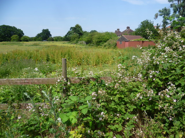
The eastern edge of Fryent Country Park
Fryent Country Park has been kept to show how much of Middlesex looked before the suburban expansion of London in the 1920s and 1930s. There are 23 hay meadows and seven miles of hedgerows, four woods and 20 ponds.
Fryent Country Park is bisected by Fryent Way. The part of the Country Park to the east of Fryent Way is dominated by Gotfords Hill and the view from the open top of the hill includes the wooded Barn Hill on the other side of Fryent Way, the Wembley Arch, Harrow-on-the-Hill and the hills to the north. It is also on the Capital Ring.
The hedgerows on this side of Fryent Country Park, which is in the former parish of Kingsbury, were cut out of the original woodland by the process of 'assarting'. As each farmer made clearings in the woodland, so the woodland was pushed back until only the hedges remained. This gave rise to the variety of field shapes and sizes that can be seen today. On the other hand the hedges to the west of Fryent Way on the Barn Hill side were mostly planted.
This is below the eastern edge of Gotfords Hill, looking across a horse paddock with the backs of the houses in Slough Lane on the right.
 Map © Crown Copyright")
TIP: Click the map for more Large scale mapping
- Grid Square
- TQ2088, 227 images (more nearby 🔍)
- Photographer
- Marathon (more nearby)
- Date Taken
- Wednesday, 1 July, 2015 (more nearby)
- Submitted
- Wednesday, 1 July, 2015
- Subject Location
-
OSGB36:
 TQ 2012 8819 [10m precision]
WGS84: 51:34.7869N 0:16.0704W - Camera Location
-
OSGB36: TQ 2011 8812
- View Direction
- NORTH (about 0 degrees)