2015
SJ1378 : Tower on Garreg Hill, Whitford (3)
taken 9 years ago, near to Whitford, Flintshire/Sir y Fflint, Wales
This is 1 of 4 images, with title starting with Tower on Garreg Hill, Whitford in this square
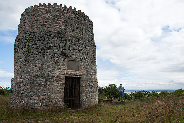
Tower on Garreg Hill, Whitford (3)
This round tower on the summit of Garreg Hill overlooking the Dee estuary, is supposedly a Roman pharos (a lighthouse), but there is no evidence to support this. It probably dates from the early C17 when it may have been a windmill, and is labelled as such on a Mostyn estate map of 1732. It has since been described as an unlit maritime beacon, and as a watchtower serving as a look out for pirates. It was restored in 1897 by Baron Mostyn to commemorate the Diamond Jubilee of Queen Victoria.
 Map © Crown Copyright")
TIP: Click the map for more Large scale mapping
- Grid Square
- SJ1378, 11 images (more nearby 🔍)
- Photographer
- Mike Searle (more nearby)
- Date Taken
- Thursday, 23 July, 2015 (more nearby)
- Submitted
- Wednesday, 5 August, 2015
- Subject Location
-
OSGB36:
 SJ 1336 7827 [10m precision]
WGS84: 53:17.6567N 3:18.0790W - Camera Location
-
OSGB36: SJ 1336 7827