2015

SE3134 : Mural on Mabgate, Leeds

taken 9 years ago, near to Leeds, England
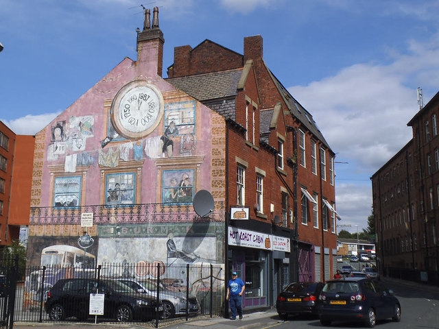
Mural on Mabgate, Leeds
See also SE3134 : Mural on Wall of Property in Mabgate. The mural includes a "time clock" showing dates from 1880 to 1987. Apparently "The building, which used to be a stone cutting mill, was redecorated in 1987 by Surmak Products. What makes it particularly special, is the fact that the people in the windows were based on their employees" (source: LinkExternal link ). The ground floor is now the Hot Roast Cabin.
Mabgate, Leeds

Mabgate lies just north-east of the city centre, sandwiched between the busy A61 road to the west and residential areas to the east.

As the name implies it was one of the original roads into the city, and allegedly derives its name from Mable-gate, Mable being "a middle English term used to describe loose women", indicating a location where what we would now call sex workers could be found.

The area later developed from the end of the 18th century "as a series of woollen mills along the Lady Beck and by 1850 had become a dense area of industry and workers' houses" (Leeds City Council Mabgate Development Framework, 2007, quoted on Wikipedia).

Towards the end of the 20th century it became known as a centre of entertainment again, but the last two pubs (City of Mabgate and the Black Horse) have finally closed. Now (early 21st century) it is an area of "urban fringe" - small businesses, former factories, closed pubs and so on.


Creative Commons Licence [Some Rights Reserved]   © Copyright Stephen Craven and licensed for reuse under this Creative Commons Licence.
Geographical Context: Business, Retail, Services Date: 1987 other tags: Urban Mural Click a tag, to view other nearby images.
This photo is linked from: Automatic Clusters: · Mabgate Mills [4] ·
1:50,000 Modern Day Landranger(TM) Map © Crown Copyright
+
+
1:50,000 Modern Day Landranger(TM) Map © Crown Copyright
TIP: Click the map for more Large scale mapping
Grid Square
SE3134, 389 images   (more nearby 🔍)
Photographer
Stephen Craven   (more nearby)
Date Taken
Tuesday, 25 August, 2015   (more nearby)
Submitted
Wednesday, 26 August, 2015
Subject Location
OSGB36: geotagged! SE 3103 3414 [10m precision]
WGS84: 53:48.1584N 1:31.8202W
Camera Location
OSGB36: geotagged! SE 3104 3412
View Direction
North-northwest (about 337 degrees)
Clickable map
+
NW N NE
W Go E
SW S SE
Image classification(about): Geograph
This page has been viewed about 195 times
You are not logged in login | register