1994
SN8057 : Southward down the Upper Towy at Nant-y-stalyn on the drovers' road through the Cambrian Mountains
taken 30 years ago, near to Nant-Ystalwyn [other Features], Powys, Great Britain
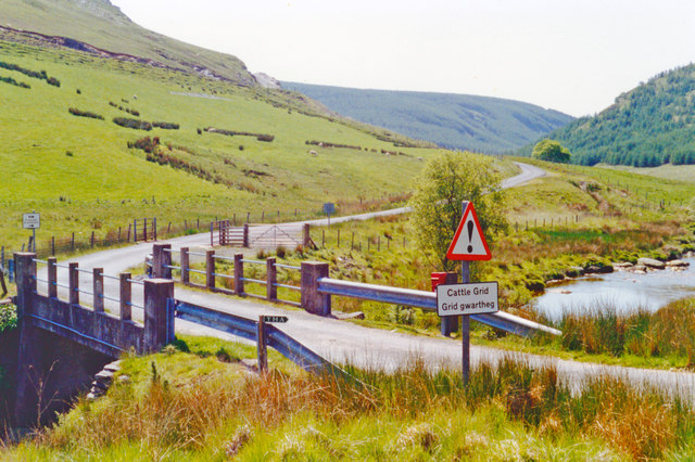
Southward down the Upper Towy at Nant-y-stalyn on the drovers' road through the Cambrian Mountains
View southward, in the remotest of spots on the drovers' road, which runs over the mountains from Tregaron on the River Teifi in Cardigan. This is a very minor road, of about 12 miles almost completely devoid of traffic, to Abergwesyn and Beulah, from where the cattle were driven on tracks in the southward-flowing valleys to Builth Wells etc. on the River Wye. From here southward is an equally uninhabited road beside the River Towy for about 15 almost isolated miles to Llandovery. The river here forms the boundary between Cardigan/Ceredigion with Brecknock (now part of Powys). (See also SN8057 : Northward up the headwaters of the River Towy at Nant-y-stalyn and SN8057 : Westward on the drovers' road from Tregaron at the River Towy bridge at Nant-y-stalyn.)
 Map © Crown Copyright")
TIP: Click the map for more Large scale mapping
- Grid Square
- SN8057, 186 images (more nearby 🔍)
- Photographer
- Ben Brooksbank (more nearby)
- Date Taken
- Thursday, 16 June, 1994 (more nearby)
- Submitted
- Wednesday, 25 November, 2015
- Subject Location
-
OSGB36:
 SN 803 571 [100m precision]
WGS84: 52:11.9518N 3:45.1260W - Camera Location
-
OSGB36: SN 803 571
- View Direction
- SOUTH (about 180 degrees)