TQ3403 : Roedean Vale, Roedean
taken 8 years ago, near to Ovingdean, Brighton And Hove, England
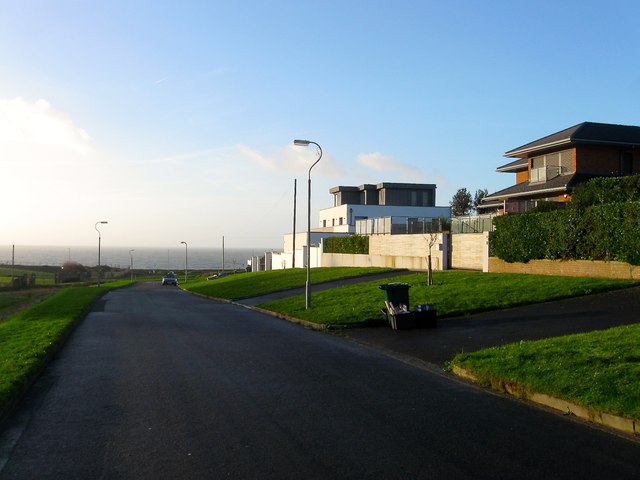
A rather exclusive suburb on the eastern side of Brighton that was developed from the 1920s onwards. Roedean was the name initially applied to a gap in the cliffs in the neighbouring parish of Rottingdean to the south and later to an early 19th century farm which stood to the south of the old coast road. By the 1870s only Garden House in the Rottingdean part had been added. In 1897 the old coast road was closed when cliffs collapsed at Black Rock and in its place a new road was constructed which follows the course of the modern B2118. In 1900 a row of coastguard cottages were built to replace an older station that had also been lost to the same cliff collapse these still stand and today form Roedean Terrace. In 1928 Brighton Corporation acquired both the parishes of Ovingdean and Rottingdean and to protect the newly acquired cliffs the sea defences known as the Undercliff Walk were constructed between 1930-33. With the cliffs stabilised a new cliff top road was opened in 1932 called Marine Drive which later became the A259. In the process of its construction the old Roedean Farm was purchased and demolished. The suburb itself also began to develop within the old Ovingdean portion with western parts of Roedean Way and Roedean crescent developed as far as Roedean Path by the 1950s. The eastern portion up to Roedean Vale was completed by the end of the 1960s. South of the settlement in the old Rottingdean part the area was kept open with the few houses built eventually demolished to make way for the miniature golf course. Roedean is famous for its girls school that moved to its current site in 1898 that is located south east of the suburb.
A former parish that is now an outer suburb of Brighton. The parish was square in shape except for the south east corner which stretched up the western slope of High Hill. It was bounded to the west by Brighton, to the north west by Falmer and to the north east, east and along the cliffs to the south by Rottingdean. The village itself lies within a dip in the downs sheltered from the prevailing south westerly winds by Cattle Hill. For much of its history it was split into two manors controlling the western and eastern parts of the surrounding downland. The western manor house was originally located in the field to the immediate north of the church until moved to its current position in the 16th century and renamed Ovingdean Grange in the 19th. The eastern part was owned by Lewes Priory from the 13th century until its dissolution in 1537 and was farmed from the mid 18th century onwards by Ovingdean Hall Farm. Parts of the western manor were acquired by Brighton Corporation in 1913 and would later become the suburb of Whitehawk and East Brighton Park. The rest of the parish was acquired in 1928 along with neighbouring Rottingdean after which residential development began on Long Hill, initially as shacks and bungalows which were later rebuilt after the war. To the south west the upmarket suburb of Roedean was developed at this time whilst on the eastern side adjacent to Falmer Road a small estate grew up around Eley Drive which is now considered part of Rottingdean along with Longhill School to the north.
Much of the parish is still downland and retains a secluded rural feel despite being part of Brighton. The main roads into the village are via Greenways from the coastal A259 and Ovingdean Road heading westwards from Falmer Road, the B2123. An ancient route headed west via Red Hill to Brighton but is now a bridleway. Part of the Rottingdean to Falmer route runs through the eastern portion of the parish whilst an old route running parallel along higher ground is now a bridleway. The church dates from the 11th century and a school was built in 1873 but closed due to falling numbers in 1907. A secondary school was built in the 1970s next to Falmer Road but is considered part of Rottingdean, another in 1976 to cover the suburb of Whitehawk which closed in 2005 and is now part of City College, whilst the former mansion Ovingdean Hall has been used as three separate types of educational facility since 1890. Other than farmsteads the village contained no other services, probably due to the closeness of Rottingdean village, until it acquired a local shop and post office in the 1920s to service the growing residential developments along Long Hill which it still retains in 2015. A golf course was constructed in 1893 on Red Hill where the starting point of Brighton Racecourse was laid out about a century earlier though later shortened. Whitehawk FC's football ground also lies within the old parish in Black Rock Valley.
 Map © Crown Copyright")
- Grid Square
- TQ3403, 177 images (more nearby 🔍)
- Photographer
- Simon Carey (more nearby)
- Date Taken
- Wednesday, 23 December, 2015 (more nearby)
- Submitted
- Thursday, 24 December, 2015
- Subject Location
-
OSGB36:
 TQ 3478 0330 [10m precision]
WGS84: 50:48.8146N 0:5.2940W - Camera Location
-
OSGB36: TQ 3481 0342
- View Direction
- South-southwest (about 202 degrees)