2009
SO5011 : Tunnel mouth at Monmouth Troy
taken 15 years ago, near to Monmouth/Trefynwy, Monmouthshire/Sir Fynwy, Wales
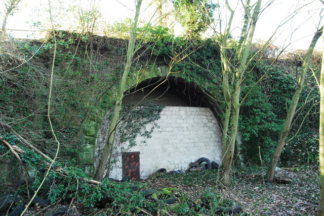
Tunnel mouth at Monmouth Troy
The Monmouth end of the former railway tunnel at Monmouth Troy, through which the line made its way to Dingestow, Raglan, Usk and Pontypool Road. This was part of the (deep breath) Coleford, Monmouth, Usk and Pontypool Railway (CMU&PR), which like most early railway companies must have spent most of their capital on ink to write down their rather unwieldy name. The line opened throughout in 1857 and, like most small railway companies, its parent company had bigger plans than were ever achieved in reality. A link to Coleford did open, but not under the CMU&PR, and it was closed by 1917 as the rails were needed on the Western Front to help the war effort. A closure plan in 1954 was rejected and the service increased to a staggering 11 trains a day. However, a national rail strike in 1955 put paid to any attempt to run the line, and the track between Monmouth and Usk was dismantled in 1960. This picture at Link shows the tunnel mouth: an interesting point is that all the structures on the line were built for double track but the second track was never added. Even here, where double track would appear to run through the tunnel, one of the lines is a siding which ended just at the far end of the tunnel. See Link (Archive Link ) for more info, it's where I lifted most of this description from.
 Map © Crown Copyright")
TIP: Click the map for more Large scale mapping
- Grid Square
- SO5011, 90 images (more nearby 🔍)
- Photographer
- John Winder (more nearby)
- Date Taken
- Saturday, 3 January, 2009 (more nearby)
- Submitted
- Monday, 28 March, 2016
- Subject Location
-
OSGB36:
 SO 5086 1180 [10m precision]
WGS84: 51:48.1603N 2:42.8434W - Camera Location
-
OSGB36: SO 5087 1180
- View Direction
- WEST (about 270 degrees)