2016
SM9701 : Rock Cottage (Cunnigar)
taken 8 years ago, near to Pembroke, Pembrokeshire/Sir Benfro, Wales
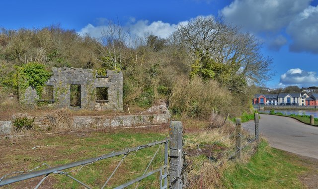
Rock Cottage (Cunnigar)
ROCK COTTAGE (CUNNIGAR), MONKTON PILL.
NPRN 524975.
Unitary (Local) Authority - Pembrokeshire.
Type of Site
COTTAGE.
Broad Class
Domestic
Period - Post Medieval.
Site Description -
A rectangular building measuring some 9m x 5m and orientated approximately east/west is shown on OS 1st edition 25in. The cottage has a porch to its western elevation and a small separate building to the east. Tracks lead southwards towards the boathouse (NPRN 525234) and to the former warehouses and coal yard on the south side of Monkton Bridge. The cottage's name had been changed by 2nd edition OS mapping to 'Cunnigar' (rabbit warren?). Modern aerial photography appears to show a roofless 3-bayed building within an area of scrub.
Sources include:
Dyfed Archaeological Trust HER Ref 20084, 31940.
NAW Aerial photography 2006-9.
OS 1st edition 25in mapping.
Maritime Officer, RCAHMW, November 2012.
 Map © Crown Copyright")
TIP: Click the map for more Large scale mapping
- Grid Square
- SM9701, 64 images (more nearby 🔍)
- Photographer
- Deborah Tilley (more nearby)
- Date Taken
- Thursday, 31 March, 2016 (more nearby)
- Submitted
- Thursday, 31 March, 2016
- Subject Location
-
OSGB36:
 SM 9797 0165 [10m precision]
WGS84: 51:40.6312N 4:55.4106W - Camera Location
-
OSGB36: SM 9797 0163
- View Direction
- North-northeast (about 22 degrees)