2016
NS4175 : Ballagan Beds near the Witch's Tunnel
taken 8 years ago, near to Bellsmyre, West Dunbartonshire, Scotland
Ballagan Beds near the Witch's Tunnel
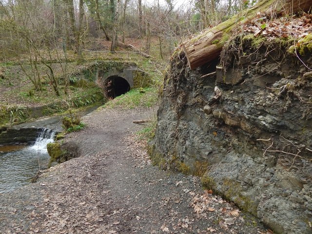
The exposed rock in the right foreground is an example of Ballagan Beds. It is near a NS4175 : Confluence of burns; in that picture, which is a view in the opposite direction from above the tunnel entrance, the outcrop is on the left, where the path turns out of sight.
The rock itself contains layers of crumbly mudstone, and some paler layers of cementstone nodules. The difference between the layers is more apparent in a view of a larger, taller exposure elsewhere: NS4178 : Ballagan Beds in Auchenreoch Glen. See that picture for more information about Ballagan Beds.
The type location, and the place from which this distinctive formation takes its name, is Ballagan Glen: NS5780 : The Ballagan Beds, Ballagan Glen.
Witch's Tunnel :: NS4176
The local name for a tunnel, 164 feet long and 10 feet wide, through which the Garshake Burn flows beneath an avenue leading to Overtoun House. See Link for much more information about the avenue as a whole.
As noted there, the avenue, which was officially opened in 1895, had to cross the deep glen of the Garshake Burn here; to that end, an embankment was formed, consisting of about 50,000 cubic yards of material. The Garshake Burn was culverted through that embankment by means of this tunnel.
Overtoun Bridge Link is part of the same avenue, and dates from about the same period. By means of that bridge, the avenue is carried over the glen of the Overtoun Burn.
 Map © Crown Copyright")
TIP: Click the map for more Large scale mapping
- Grid Square
- NS4175, 113 images (more nearby 🔍)
- Photographer
- Lairich Rig (more nearby)
- Date Taken
- Friday, 18 March, 2016 (more nearby)
- Submitted
- Sunday, 3 April, 2016
- Subject Location
-
OSGB36:
 NS 4179 7596 [10m precision]
WGS84: 55:57.0326N 4:32.1180W - Camera Location
-
OSGB36: NS 4180 7596
- View Direction
- West-northwest (about 292 degrees)