2016
NY9322 : Landslip at Grassholme Reservoir
taken 8 years ago, near to Thringarth, County Durham, England
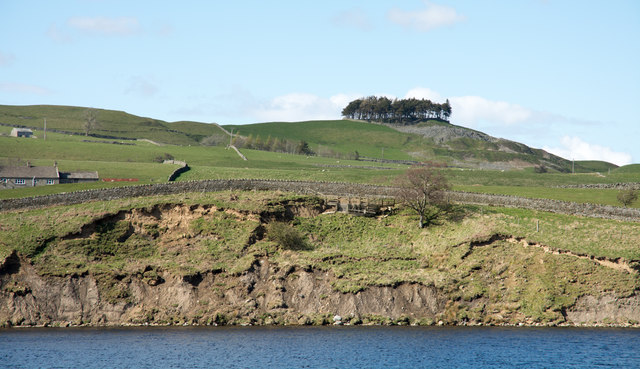
Landslip at Grassholme Reservoir
There's been some significant slippage of ground on the north side of Grassholme Reservoir. Certainly some of the damage occurred over the wet winter of 2015/2016 but the photographer is unsure whether all of the movement occurred over that period. The view is across the reservoir from the path on the south side; notices declare the path on the north side to be closed but there are no barriers to prevent walking there and the damage to the path can be passed with appropriate care.
 Map © Crown Copyright")
TIP: Click the map for more Large scale mapping
- Grid Square
- NY9322, 25 images (more nearby 🔍)
- Photographer
- Trevor Littlewood (more nearby)
- Date Taken
- Saturday, 30 April, 2016 (more nearby)
- Submitted
- Sunday, 1 May, 2016
- Subject Location
-
OSGB36:
 NY 939 225 [100m precision]
WGS84: 54:35.8855N 2:5.7465W - Camera Location
-
OSGB36: NY 939 222
- View Direction
- North-northwest (about 337 degrees)