2015
SE2436 : National Ordnance Factory, Newlay, Leeds
taken 9 years ago, near to Horsforth, Leeds, England
This is 1 of 12 images, with title National Ordnance Factory, Newlay, Leeds in this square
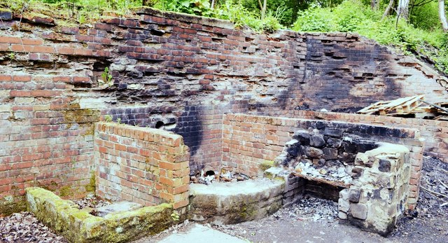
National Ordnance Factory, Newlay, Leeds
Newlay today is a quiet backwater with very little commerce, but in Victorian times it contained a variety of industries. Included were dyeworks. Mills, tanneries, quarries and glue factories which were mainly situated in a very small area between the river and canal bridges. The workforce must have totalled over 1000.
During the first world war in 1916, a National Ordnance Factory opened in Newlay, manufacturing shells. It was situated down Hunters Greave, which lies between the river and canal and covered five acres. Such was the urgency of the time it only took six months to erect.
The factory was staffed by men at first, but one day in June 1916, thirty blue-overcalled women took their place in the machine shop; this was absolutely unheard of in those days! It caused great discussion amongst the men on how they would stick it. Stick it they did though, their numbers swelling to several hundred and bringing the total workforce to over 1000.
There were many social and sporting activities organized, where the workers could find relief from their long hard days in the sheds. These included male (and female) football and cricket teams, angling and tennis clubs, quoits and gymkhanas to name some.
The workers came from all walks of life including many Newlay, Horsforth and Bramley residents. Others came from further afield, arriving at Newlay Station by train to face their arduous day in the factory.
Today the site is used as a Scout Camp.
See other images of National Ordnance Factory, Newlay, Leeds
 Map © Crown Copyright")
TIP: Click the map for more Large scale mapping
- Grid Square
- SE2436, 563 images (more nearby 🔍)
- Photographer
- Mark Stevenson (more nearby)
- Date Taken
- Wednesday, 20 May, 2015 (more nearby)
- Submitted
- Tuesday, 10 May, 2016
- Subject Location
-
OSGB36:
 SE 2441 3663 [10m precision]
WGS84: 53:49.5222N 1:37.8392W - Camera Location
-
OSGB36: SE 2441 3664