2016
TG2712 : Bridge in Rackheath Park
taken 8 years ago, near to New Rackheath, Norfolk, England
This is 1 of 4 images, with title Bridge in Rackheath Park in this square
Bridge in Rackheath Park
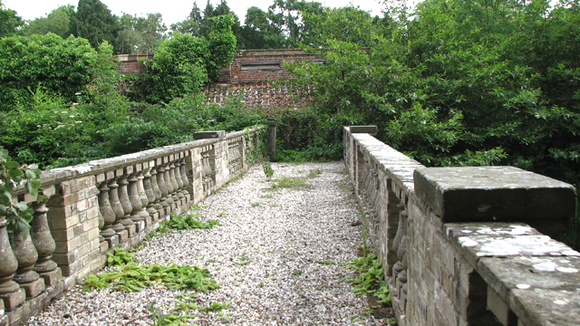
This ornamental bridge dates from between 1886 and 1919 when the lake was enlarged and is Grade II listed. It was built with gault brick and has limestone and stucco details, three elliptical arches with rusticated brick voissoirs > Link and rusticated brick piers. The parapet has a moulded rail, brick panels and stone balusters. The bridge spans the lake situated a short distance to the north of Rackheath Hall and once used to link the kitchen garden (now gone) and the former estate road, but has since been made inaccessible by a padlocked gate at the south end and a barrage of barbed wire at the north end.
 Map © Crown Copyright")
TIP: Click the map for more Large scale mapping
- Grid Square
- TG2712, 228 images (more nearby 🔍)
- Photographer
- Evelyn Simak (more nearby)
- Date Taken
- Friday, 17 June, 2016 (more nearby)
- Submitted
- Friday, 17 June, 2016
- Subject Location
-
OSGB36:
 TG 2749 1268 [10m precision]
WGS84: 52:39.8442N 1:21.7628E - Camera Location
-
OSGB36: TG 2748 1270
- View Direction
- South-southeast (about 157 degrees)